
Ficheiro:16May-21May1940-Fall Gelb.svg

Dimensões desta antevisão em PNG do ficheiro SVG: 773 × 600 píxeis Outras resoluções: 309 × 240 píxeis | 619 × 480 píxeis | 990 × 768 píxeis | 1 280 × 993 píxeis | 2 560 × 1 987 píxeis | 889 × 690 píxeis.
Imagem numa resolução maior (ficheiro SVG, de 889 × 690 píxeis, tamanho: 2,06 MB)
|
|
Esta imagem provém do Wikimedia Commons, um acervo de conteúdo livre da Wikimedia Foundation que pode ser utilizado por outros projetos.
|
Descrição do ficheiro
| Descrição |
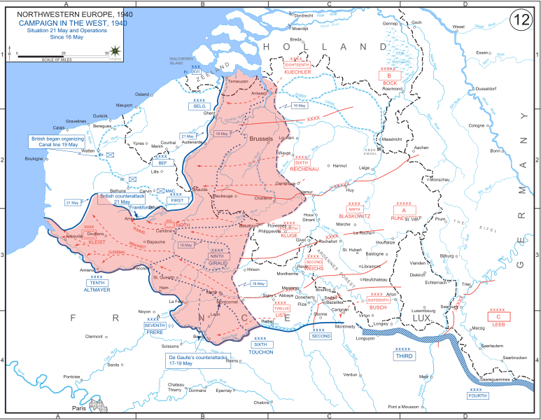
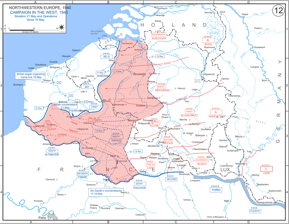
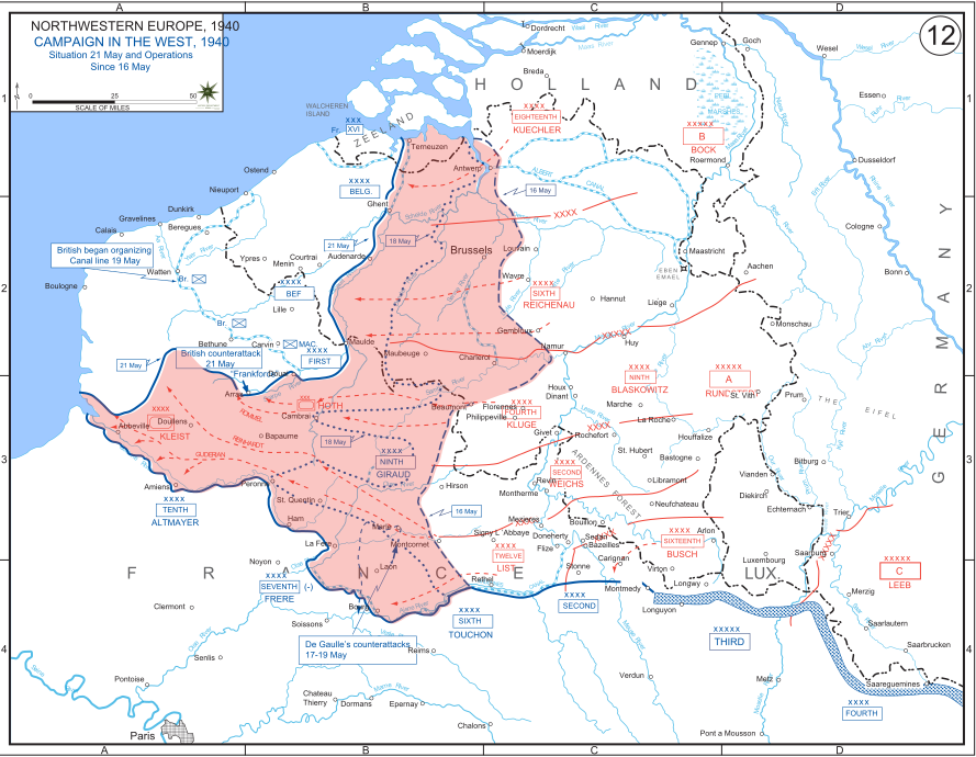
English: The German advance between 16 May and 21 May 1940. The red area denotes the territory captured by Germany during this time. The German field armies and Corps are shown in red. The operating area of the various Belgian, British, and French field armies and Army groups are shown in blue. The checkered white and blue area denotes the French Maginot Line. The commanders of the various units are shown under their respective formation. Solid lines represent the boundaries between each major unit. Dotted lines depict lines of advance. Key dates are shown in boxes. |
| Data | |
| Origem | Archive link to original website used for the map and the archive link to the map source page. Current link to map, and link to map source page. |
| Autor | The History Department of the United States Military Academy |
| Outras versões |
|


Licenciamento
Esta imagem é um trabalho de um soldado ou funcionário do Exército dos Estados Unidos, tirada ou feita durante o curso de uma tarefa oficial. Como trabalho do Governo Federal dos Estados Unidos, a imagem está em domínio público.
|
 |
Histórico do ficheiro
Clique uma data e hora para ver o ficheiro tal como ele se encontrava nessa altura.
| Data e hora | Miniatura | Dimensões | Utilizador | Comentário | |
|---|---|---|---|---|---|
| atual | 19h07min de 29 de dezembro de 2011 | | 889 × 690 (2,06 MB) | Zscout370 | The text was displaying oddly in this SVG. |
| 19h07min de 29 de dezembro de 2011 |  | 889 × 690 (463 kB) | Addihockey10 | test | |
| 02h58min de 24 de setembro de 2010 |  | 889 × 690 (334 kB) | Tazadeperla | {{Information |Description={{en|1=Vector version of file 1940FranceBlitz.jpg}} |Source=http://www.dean.usma.edu/history/web03/atlases/ww2%20europe/WWIIEuropeIndex.html |Author=The History Dept at the United States Army Academy |Date= |Permission= |other_v |
Utilização local do ficheiro
A seguinte página usa este ficheiro:
Utilização global do ficheiro
As seguintes wikis usam este ficheiro:
- af.wikipedia.org
- ar.wikipedia.org
- azb.wikipedia.org
- bn.wikipedia.org
- br.wikipedia.org
- bs.wikipedia.org
- ca.wikipedia.org
- cs.wikipedia.org
- da.wikipedia.org
- en.wikipedia.org
- fi.wikipedia.org
- fr.wikipedia.org
- gl.wikipedia.org
- he.wikipedia.org
- id.wikipedia.org
- it.wikipedia.org
- ja.wikipedia.org
- ko.wikipedia.org
- lt.wikipedia.org
- lv.wikipedia.org
- nl.wikipedia.org
- no.wikipedia.org
- pl.wikipedia.org
- ro.wikipedia.org
- ru.wikipedia.org
- simple.wikipedia.org
- sl.wikipedia.org
- sr.wikipedia.org
- th.wikipedia.org
Ver mais utilizações globais deste ficheiro.