
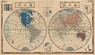
Ficheiro:1848 Japanese Map of the World in Two Hemispheres - Geographicus - World-shincho-1848.jpg

Imagem numa resolução maior (5 000 × 2 925 píxeis, tamanho: 4,6 MB, tipo MIME: image/jpeg)
|
|
Esta imagem provém do Wikimedia Commons, um acervo de conteúdo livre da Wikimedia Foundation que pode ser utilizado por outros projetos.
|
| Shinsei yochi zenzu (ALT: Kaei kotei tozai chikyu bankoku zenzu ) | ||||||
|---|---|---|---|---|---|---|
| Artista | ||||||
| Título |
Shinsei yochi zenzu (ALT: Kaei kotei tozai chikyu bankoku zenzu ) |
|||||
| Descrição |
English: An extraordinary Japanese woodblock map of the world dating to 1848 by Shincho Kurihara and Heibe Chojiya. This map, whose title literally translates as Newly Made Map of the Earth represents an important advancement in Japanese globular cartography. As a result of the Sakoku or Chained Country policy enforced in Japan between 1633 and 1853, Japanese cartographers had only the vaguest ideas of what lay beyond their own well mapped borders. What little knowledge available was usually transmitted through Dutch traders in Nagasaki and Chinese merchants who traded with the semi independent Ryukyu Kingdom to the south. Consequently, cartographic conventions common in Europe were slow to penetrate Japan. Until about 1840, most Japanese world maps followed 17th century European maps which tended to show California as an Island and the fictional southern continent of Terre Australis, among other anomalies. This map however, offers a more contemporary perspective generally in line with the most advanced European cartographic knowledge of the period. Here the world is presented in a double hemisphere projection - a style that first appeared in Japan around 1810 - and cartographically is quite accurate. California is reattached to the mainland, Australia is properly mapped including a separate Tasmania, New Zealand is correctly represented as two Islands, and Terre Australia has disappeared. Also of note is the abandonment of the Edo era convention of using cartouches and Chinese characters to identify geographic elements. Here most place names are rendered using the phonetic Katakana text - a uniquely Japanese adaptation to foreign linguistic borrowings. Some traditional Japanese techniques for rendering topography have also been abandoned in favor of a European style political map. However, there are several interesting examples of stippling used to render both deserts and offshore shoals - as in the Grand Banks and the Sahara. Also of note is a stylized rendering of the Great Wall of China. The whole is surrounded by a traditional Japanese border with a figural draconic motif. We have been able to identify several editions of this map, one of which has an appended text block in the lower left quadrant and some of which have a larger text block above the map proper. This example has neither and most likely represents the earliest state of the map. A important acquisition for any serious collection of Japanese cartography. |
|||||
| Data | 1848 (dated) | |||||
| Dimensões | altura: 15 pol (38,1 cm); largura: 26 pol (66 cm) | |||||
| Número de inventário |
Geographicus link: World-shincho-1848 |
|||||
| Fonte/Fotógrafo |
|
|||||
| Permissão (Reutilizar este ficheiro) |
|
|||||
Histórico do ficheiro
Clique uma data e hora para ver o ficheiro tal como ele se encontrava nessa altura.
| Data e hora | Miniatura | Dimensões | Utilizador | Comentário | |
|---|---|---|---|---|---|
| atual | 04h54min de 24 de março de 2011 | | 5 000 × 2 925 (4,6 MB) | BotMultichillT | {{subst:User:Multichill/Geographicus |link=http://www.geographicus.com/P/AntiqueMap/World-shincho-1848 |product_name=1848 Japanese Map of the World in Two Hemispheres |map_title=Shinsei yochi zenzu (ALT: Kaei kotei tozai chikyu bankoku zenzu ) |descriptio |
Utilização local do ficheiro
A seguinte página usa este ficheiro:
Utilização global do ficheiro
As seguintes wikis usam este ficheiro:
- fi.wikipedia.org