
Ficheiro:1945-04-15GerWW2BattlefrontAtlas.jpg

Dimensões desta antevisão: 609 × 600 píxeis. Outras resoluções: 244 × 240 píxeis | 488 × 480 píxeis | 780 × 768 píxeis | 1 236 × 1 217 píxeis.
Imagem numa resolução maior (1 236 × 1 217 píxeis, tamanho: 1,27 MB, tipo MIME: image/jpeg)
|
|
Esta imagem provém do Wikimedia Commons, um acervo de conteúdo livre da Wikimedia Foundation que pode ser utilizado por outros projetos.
|
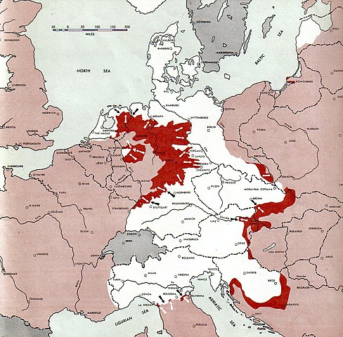
Atlas of the World Battle Fronts - War against Germany: 1945-04-15
← Previous map: 1945-04-01
→ Next map: 1945-05-01
Descrição do ficheiro
| Descrição |
Neutral nations (Sweden, Switzerland, Spain, etc.)
Under Allied control
Allied forces
Axis forces
  July 1, 1943 to June 30 1945 To the Secretary of War". (See Cover, Forward and Map details)  |
| Data | |
| Origem | Document "Atlas of the World Battle Fronts in Semimonthly Phases to August 15th 1945: Supplement to The Biennial report of the Chief of Staff of the United States Army July 1, 1943 to June 30 1945 To the Secretary of War" |
| Autor | Army Map Service |
| Permissão (Reutilizar este ficheiro) |
Public Domain: Work of US army |
Licenciamento
Esta imagem é um trabalho de um soldado ou funcionário do Exército dos Estados Unidos, tirada ou feita durante o curso de uma tarefa oficial. Como trabalho do Governo Federal dos Estados Unidos, a imagem está em domínio público.
|
 |
Histórico do ficheiro
Clique uma data e hora para ver o ficheiro tal como ele se encontrava nessa altura.
| Data e hora | Miniatura | Dimensões | Utilizador | Comentário | |
|---|---|---|---|---|---|
| atual | 10h06min de 28 de agosto de 2011 | | 1 236 × 1 217 (1,27 MB) | Cropbot | upload cropped version, operated by User:Finavon. Summary: caption cropped |
| 20h13min de 24 de dezembro de 2007 |  | 1 274 × 1 752 (1,79 MB) | Mike Young | {{Information |Description= thumb|left|75pxthumb|right|75pxMap of the front against Germany: This map is taken from the source "Atlas of the World Battle Fronts in Semimonthly |
Utilização local do ficheiro
A seguinte página usa este ficheiro:
Utilização global do ficheiro
As seguintes wikis usam este ficheiro:
- ar.wikipedia.org
- az.wikipedia.org
- bg.wikipedia.org
- da.wikipedia.org
- de.wikipedia.org
- el.wikipedia.org
- en.wikipedia.org
- en.wikisource.org
- fr.wikipedia.org
- hr.wikipedia.org
- id.wikipedia.org
- mk.wikipedia.org
- no.wikipedia.org
- ru.wikipedia.org
- sh.wikipedia.org
- sr.wikipedia.org
- ta.wikipedia.org
- vi.wikipedia.org
- www.wikidata.org