
Ficheiro:Adams onis map.png
Imagem numa resolução maior (800 × 654 píxeis, tamanho: 226 kB, tipo MIME: image/png)
|
|
Esta imagem provém do Wikimedia Commons, um acervo de conteúdo livre da Wikimedia Foundation que pode ser utilizado por outros projetos.
|

|
File:Adams-Onís treaty map-en.svg é uma versão vetorial deste ficheiro. Ela deve ser usada em vez desta imagem em formato raster, se não for de qualidade inferior.
File:Adams onis map.png → File:Adams-Onís treaty map-en.svg
Para mais informações, consulte Ajuda:SVG. |
 |
Descrição do ficheiro
Please state the map from which this was traced, or the other cartographic sources that provided the information allowing you to create the boundaries show.[citation needed]
en:User:Citynoise is the creator at stated at source: I, Citynoise, am the creator of this map and hereby release it per the ShareAlike Attribution license. See www.radicalcartography.net for more.
Licenciamento
- Pode:
- partilhar – copiar, distribuir e transmitir a obra
- recombinar – criar obras derivadas
- De acordo com as seguintes condições:
- atribuição – Tem de fazer a devida atribuição da autoria, fornecer uma hiperligação para a licença e indicar se foram feitas alterações. Pode fazê-lo de qualquer forma razoável, mas não de forma a sugerir que o licenciador o apoia ou subscreve o seu uso da obra.
- partilha nos termos da mesma licença – Se remisturar, transformar ou ampliar o conteúdo, tem de distribuir as suas contribuições com a mesma licença ou uma licença compatível com a original.
Histórico do ficheiro
Clique uma data e hora para ver o ficheiro tal como ele se encontrava nessa altura.
| Data e hora | Miniatura | Dimensões | Utilizador | Comentário | |
|---|---|---|---|---|---|
| atual | 18h56min de 18 de julho de 2012 | | 800 × 654 (226 kB) | Kmusser | rm Russian claim to Oregon (was dropped by the timeframe of this map - see Adams-Onis talk page) |
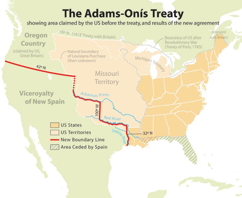
| 19h42min de 10 de julho de 2006 |  | 800 × 654 (227 kB) | JMPerez~commonswiki | == Summary == Map showing the results of the Adams-Onís Treaty of 1819. I, Citynoise, am the creator of this map and hereby release it per the ShareAlike Attribution license. See www.radicalcartography.net for more. From English Wikipedia. == Licensin |
Utilização local do ficheiro
A seguinte página usa este ficheiro:
Utilização global do ficheiro
As seguintes wikis usam este ficheiro:
- ar.wikipedia.org
- ca.wikipedia.org
- cs.wikipedia.org
- da.wikipedia.org
- de.wikipedia.org
- en.wikipedia.org
- John Quincy Adams
- James Monroe
- Adams–Onís Treaty
- Moses Austin
- Spanish Canadians
- Spanish Texas
- Presidency of James Monroe
- User:Esemono/British
- Territorial evolution of the Caribbean
- List of territorial claims and designations in Colorado
- Early history of the Arkansas Valley in Colorado
- History of U.S. foreign policy, 1801–1829
- Long's Expedition of 1820
- eu.wikipedia.org
- fa.wikipedia.org
- fi.wikipedia.org
- he.wikipedia.org
- hu.wikipedia.org
- id.wikipedia.org
- it.wikipedia.org
- ja.wikipedia.org
- ko.wikipedia.org
- nl.wikipedia.org
- no.wikipedia.org
- pl.wikipedia.org
- pnb.wikipedia.org
- ro.wikipedia.org
- ru.wikipedia.org
- simple.wikipedia.org
- sr.wikipedia.org
- sv.wikipedia.org
- th.wikipedia.org
- uk.wikipedia.org
- ur.wikipedia.org
- www.wikidata.org
- zh.wikipedia.org