
Ficheiro:AgadezMNJattacks0807.png
AgadezMNJattacks0807.png (363 × 300 píxeis, tamanho: 105 kB, tipo MIME: image/png)
|
|
Esta imagem provém do Wikimedia Commons, um acervo de conteúdo livre da Wikimedia Foundation que pode ser utilizado por outros projetos.
|
Descrição do ficheiro
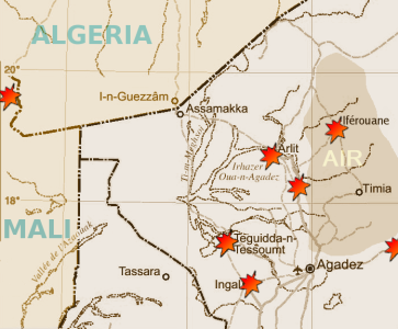
| Descrição | Map of the summer 2007 fighting between the tuareg insugenciey and government forces in the northwest of Niger | |||
| Data | ||||
| Origem |
Highly adapted using the Gimp from http://www.un.org/Depts/Cartographic/map/profile/niger.pdf
|
|||
| Autor | T L Miles |
Highly adapted from http://www.un.org/Depts/Cartographic/map/profile/niger.pdf
| This image is a map derived from a United Nations map.
Unless stated otherwise, UN maps are to be considered in the public domain. This applies worldwide. UN maps are, in principle, open source material and you can use them in your work or for making your own map. UN requests however that you delete the UN name, logo and reference number upon any modification to the map. Content of your map will be your responsibility. You can state in your publication, if you wish, something like: based on UN map … (map name, map number, revision number and date). See: Geospatial Information Section. And: Geospatial, location data for a better world. |
 |
Licenciamento
| Eu, titular dos direitos de autor desta obra, dedico-a ao domínio público, com aplicação em todo o mundo. Nalguns países isto pode não ser legalmente possível; se assim for: Concedo a todos o direito de usar esta obra para qualquer fim, sem quaisquer condições, a menos que tais condições sejam impostas por lei. |
Histórico do ficheiro
Clique uma data e hora para ver o ficheiro tal como ele se encontrava nessa altura.
| Data e hora | Miniatura | Dimensões | Utilizador | Comentário | |
|---|---|---|---|---|---|
| atual | 19h13min de 30 de agosto de 2007 | | 363 × 300 (105 kB) | T L Miles | {{Information |Description= Map of the summer 2007 fighting between the tuareg insugenciey and government forces in the northwest of Niger |Source=Highly adapted using the Gimp from http://www.un.org/Depts/Cartographic/map/profile/niger.pdf {{UN map}} |
Utilização local do ficheiro
A seguinte página usa este ficheiro:
Utilização global do ficheiro
As seguintes wikis usam este ficheiro:
- de.wikipedia.org
- en.wikipedia.org
- es.wikipedia.org
- fi.wikipedia.org
- id.wikipedia.org
- sv.wikipedia.org
- www.wikidata.org