
Ficheiro:Antarctica, Argentina territorial claim.svg

Dimensões desta antevisão em PNG do ficheiro SVG: 600 × 600 píxeis Outras resoluções: 240 × 240 píxeis | 480 × 480 píxeis | 768 × 768 píxeis | 1 024 × 1 024 píxeis | 2 048 × 2 048 píxeis | 806 × 806 píxeis.
Imagem numa resolução maior (ficheiro SVG, de 806 × 806 píxeis, tamanho: 65 kB)
|
|
Esta imagem provém do Wikimedia Commons, um acervo de conteúdo livre da Wikimedia Foundation que pode ser utilizado por outros projetos.
|
| Descrição |
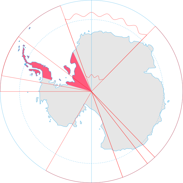
English: Map showing the territorial claim to Antarctica by the country in the filename. Also on the map are is the 60° S Parallel, Antarctic Circle, 0/180 latitude line and (in red) the borders of the claims by other states. |
| Data | |
| Origem | Generated from Antarctica by Lokal_Profil. |
| Autor | Lokal_Profil |
| Permissão (Reutilizar este ficheiro) |
A utilização deste ficheiro é regulada nos termos da licença Creative Commons - Atribuição-CompartilhaIgual 2.5 Genérica. Atribuição: Lokal_Profil
|
Histórico do ficheiro
Clique uma data e hora para ver o ficheiro tal como ele se encontrava nessa altura.
| Data e hora | Miniatura | Dimensões | Utilizador | Comentário | |
|---|---|---|---|---|---|
| atual | 20h55min de 30 de junho de 2008 | | 806 × 806 (65 kB) | Lokal Profil | {{Information |Description={{en|Map showing the territorial claim to Antarctica by the country in the filename. Also on the map are is the 60° S Parallel, Antarctic Circle, 0/180 latitude line and (in red) the borders of the claims by other states.}} |So |
Utilização local do ficheiro
As seguintes 2 páginas usam este ficheiro:
Utilização global do ficheiro
As seguintes wikis usam este ficheiro:
- af.wikipedia.org
- ar.wikipedia.org
- ast.wikipedia.org
- az.wikipedia.org
- ca.wikipedia.org
- chr.wikipedia.org
- ckb.wikipedia.org
- cs.wikipedia.org
- da.wikipedia.org
- de.wikipedia.org
- diq.wikipedia.org
- el.wikipedia.org
- en.wikipedia.org
- eo.wikipedia.org
- et.wikipedia.org
- eu.wikipedia.org
- fa.wikipedia.org
- fi.wikipedia.org
- frr.wikipedia.org
- fr.wikipedia.org
- gl.wikipedia.org
- gv.wikipedia.org
- hu.wikipedia.org
- hy.wikipedia.org
- id.wikipedia.org
- ilo.wikipedia.org
- it.wikipedia.org
- ja.wikipedia.org
Ver mais utilizações globais deste ficheiro.