Ficheiro:Antarctica, territorial claims.svg
O conteúdo da página não é suportado noutras línguas.
Origem: Wikipédia, a enciclopédia livre.

Imagem numa resolução maior(ficheiro SVG, de 820 × 820 píxeis, tamanho: 72 kB)

Descrição
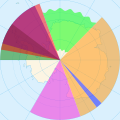
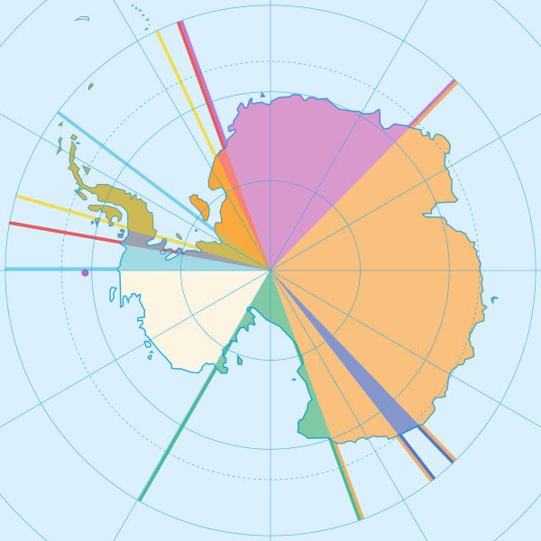
English: Map showing the territorial claims to Antarctica
 
Argentina
 
Australia
 
Chile
 
France
 
New Zealand
 
Norway
 
United Kingdom
  • The claims of Chile, Argentina and the United Kingdom partially overlap (as can be seen from the mixed colours above)
  • Norway claims two territories. Peter I Island (small circle in the top of the unclaimed territory) and Queen Maud Land. Norway has not officially elaborated as to the northernly extent of Queen Maud Land. This is why the Norwegian claim is illustrated differently from the other claims. It is however generally assumed that the Norwegian claim follows the norms of the other Antarctic claims.
  • Brazilian Antarctica (Brazil's unofficial claim) and New Swabia (Nazi Germany's historical claim) are both marked out in the code of the image but has not been coloured in. (New Swabia is lacking northernly and southernly borders on the map though)
Data
Origem
Autor Lokal_Profil
Permissão
(Reutilizar este ficheiro)
w:pt:Creative Commons
atribuição partilha nos termos da mesma licença
A utilização deste ficheiro é regulada nos termos da licença Creative Commons - Atribuição-CompartilhaIgual 2.5 Genérica.
Atribuição: Lokal_Profil
Pode:
  • partilhar – copiar, distribuir e transmitir a obra
  • recombinar – criar obras derivadas
De acordo com as seguintes condições:
  • atribuição – Tem de fazer a devida atribuição da autoria, fornecer uma hiperligação para a licença e indicar se foram feitas alterações. Pode fazê-lo de qualquer forma razoável, mas não de forma a sugerir que o licenciador o apoia ou subscreve o seu uso da obra.
  • partilha nos termos da mesma licença – Se remisturar, transformar ou ampliar o conteúdo, tem de distribuir as suas contribuições com a mesma licença ou uma licença compatível com a original.
Outras versões

Legendas

Adicione uma explicação de uma linha do que este ficheiro representa
Map showing the territorial claims to Antarctica

Elementos retratados neste ficheiro

retrata

image/svg+xml

db1a74e155cb9d4c2518fd777511c1c5701186a6

73 320 byte

820 pixel

820 pixel

Histórico do ficheiro

Clique uma data e hora para ver o ficheiro tal como ele se encontrava nessa altura.

Data e horaMiniaturaDimensõesUtilizadorComentário
atual16h42min de 8 de maio de 2020Miniatura da versão das 16h42min de 8 de maio de 2020820 × 820 (72 kB)Spesh531Norway's claim stretches to the South Pole as of June 12 2015
04h31min de 13 de outubro de 2009Miniatura da versão das 04h31min de 13 de outubro de 2009820 × 820 (71 kB)DooFisauerkraut
20h08min de 30 de junho de 2008Miniatura da versão das 20h08min de 30 de junho de 2008806 × 806 (43 kB)Lokal Profil{{Information |Description={{en|Map showing the territorial claims to Antarctica}} {{legend|#e987eb|New Zealand}} {{legend|#fcc475|Australia}} {{legend|#8282ed|France}} {{legend|#7efa72|Norway}} {{legend|#ec787f|United Kingdom}} {{legend|#6db87f|Chile}} {

As seguintes 3 páginas usam este ficheiro:

Utilização global do ficheiro

As seguintes wikis usam este ficheiro:

Ver mais utilizações globais deste ficheiro.

Metadados