
Ficheiro:Bgiusca Jirecek Line.jpg
Sem resolução maior disponível.
Bgiusca_Jirecek_Line.jpg (614 × 561 píxeis, tamanho: 176 kB, tipo MIME: image/jpeg)
|
|
Esta imagem provém do Wikimedia Commons, um acervo de conteúdo livre da Wikimedia Foundation que pode ser utilizado por outros projetos.
|
| Descrição |
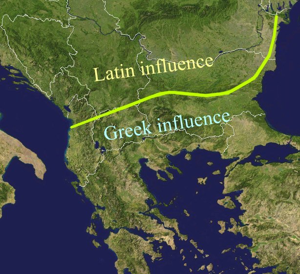
The Jirecek Line, which divides the kind of archaeological findings: to the north of the line most of the inscriptions are in Latin, to the south, they are in Greek. Aegyssos, Argamum, Histria, Tomis & Kallatis cities had greek and latin inscriptions until the VIIth cen. after JC. Jireček claimed that this line represents The division between the Greek and the Latin influence in the Balkans during the Roman Empire |
| Data | |
| Origem | Public domain NASA image via worldwind |
| Autor | Bogdan Giuşcă |
| Permissão (Reutilizar este ficheiro) |
GFDL |

|
É concedida permissão para copiar, distribuir e/ou modificar este documento nos termos da Licença de Documentação Livre GNU, versão 1.2 ou qualquer versão posterior publicada pela Free Software Foundation; sem Secções Invariantes, sem textos de Capa e sem textos de Contra-Capa. É incluída uma cópia da licença na secção intitulada GNU Free Documentation License. |
| A utilização deste ficheiro é regulada nos termos da licença Creative Commons - Atribuição-CompartilhaIgual 3.0 Não Adaptada. | ||
| ||
| Esta marca de licenciamento foi adicionada a este ficheiro durante a atualização da licença GFDL. |
Histórico do ficheiro
Clique uma data e hora para ver o ficheiro tal como ele se encontrava nessa altura.
| Data e hora | Miniatura | Dimensões | Utilizador | Comentário | |
|---|---|---|---|---|---|
| atual | 01h27min de 23 de fevereiro de 2022 | | 614 × 561 (176 kB) | Demetrios1993 | The initial version by User:Bogdan had it correct, but later, the western section of the line was altered without any justification. |
| 10h01min de 25 de março de 2018 |  | 614 × 561 (249 kB) | Trecătorul răcit | Antic shoreline and correct present-day borders | |
| 10h50min de 7 de agosto de 2014 |  | 614 × 561 (250 kB) | Spiridon Ion Cepleanu | According with Jirecek's works and the palaeography of Aegyssos, Argamum, Histria, Tomis & Kallatis cities (greek and latin inscriptions until the VIIth cen. after JC) | |
| 09h56min de 19 de abril de 2005 |  | 614 × 561 (101 kB) | Bogdan | The division between the Greek and the Latin influence in the Balkans during the Roman Empire Source: Public domain work {{GFDL}} Category:Romanian historyCategory:Roman Empire\ |
Utilização local do ficheiro
As seguintes 3 páginas usam este ficheiro:
Utilização global do ficheiro
As seguintes wikis usam este ficheiro:
- an.wikipedia.org
- ar.wikipedia.org
- ast.wikipedia.org
- ba.wikipedia.org
- bg.wikipedia.org
- ca.wikipedia.org
- ce.wikipedia.org
- cs.wikipedia.org
- cv.wikipedia.org
- de.wikipedia.org
- el.wikipedia.org
- en.wikipedia.org
- es.wikipedia.org
- et.wikipedia.org
- eu.wikipedia.org
- fa.wikipedia.org
- fr.wikipedia.org
- he.wikipedia.org
- hi.wikipedia.org
- hr.wikipedia.org
- id.wikipedia.org
- it.wikipedia.org
- ja.wikipedia.org
- ka.wikipedia.org
- ko.wikipedia.org
- la.wikipedia.org
- lt.wikipedia.org
- nl.wikipedia.org
Ver mais utilizações globais deste ficheiro.