
Ficheiro:Continental pole of inaccessibility.png

Dimensões desta antevisão: 600 × 600 píxeis. Outras resoluções: 240 × 240 píxeis | 480 × 480 píxeis | 960 × 960 píxeis.
Imagem numa resolução maior (960 × 960 píxeis, tamanho: 152 kB, tipo MIME: image/png)
|
|
Esta imagem provém do Wikimedia Commons, um acervo de conteúdo livre da Wikimedia Foundation que pode ser utilizado por outros projetos.
|
Descrição do ficheiro

|
Esta imagem de mapas (ou todas as imagens neste artigo ou categoria) deveriam ser recriadas usando gráficos vectoriais, como ficheiros SVG. Isto tem várias vantagens; veja as Commons:Media for cleanup|imagens para rever para mais informações. Se já criou um ficheiro SVG desta imagem, por favor, carregue-o. Depois do novo ficheiro SVG ter sido carregado, substitua aqui esta predefinição pela predefinição {{vector version available|nome da nova imagem.svg}}.
|
| Descrição |
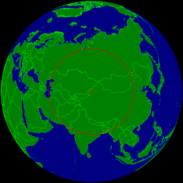
English: Spherical Earth centered on the continental pole of inaccessibility in the middle of Eurasia. The circle indicates the distance to the nearest ocean (the Caspian Sea on the left is not connected with the ocean).
Deutsch: Erdkugel, zentriert auf dem kontinentalen Pol der Unzugänglichkeit in der Mitte von Eurasien. Der Kreis zeigt den Abstand zum nächsten Ozean (das Kaspische Meer links im Bild ist nicht mit dem Ozean verbunden). |
| Data | |
| Origem | Obra do próprio |
| Autor | Timwi |
Licenciamento
| Eu, titular dos direitos de autor desta obra, dedico-a ao domínio público, com aplicação em todo o mundo. Nalguns países isto pode não ser legalmente possível; se assim for: Concedo a todos o direito de usar esta obra para qualquer fim, sem quaisquer condições, a menos que tais condições sejam impostas por lei. |
Histórico do ficheiro
Clique uma data e hora para ver o ficheiro tal como ele se encontrava nessa altura.
| Data e hora | Miniatura | Dimensões | Utilizador | Comentário | |
|---|---|---|---|---|---|
| atual | 10h20min de 24 de março de 2015 | | 960 × 960 (152 kB) | RokerHRO | optipng -o7 -i0 → 29.75% decrease |
| 23h35min de 25 de julho de 2008 |  | 960 × 960 (216 kB) | Timwi | {{Information |Description={{en|1=Spherical Earth centered on the continental pole of inaccessibility in the middle of Eurasia. The circle indicates the distance to the nearest ocean (the body of water on the left is not co |
Utilização local do ficheiro
A seguinte página usa este ficheiro:
Utilização global do ficheiro
As seguintes wikis usam este ficheiro:
- ast.wikipedia.org
- ca.wikipedia.org
- de.wikipedia.org
- en.wikipedia.org
- es.wikipedia.org
- et.wikipedia.org
- frr.wikipedia.org
- fr.wikipedia.org
- it.wikipedia.org
- ja.wikipedia.org
- lb.wikipedia.org
- pl.wikipedia.org
- ro.wikipedia.org
- sk.wikipedia.org
- uk.wikipedia.org
- vi.wikipedia.org
- www.wikidata.org
- zh.wikipedia.org