
Ficheiro:DG Ariel Plantation.jpg

Dimensões desta antevisão: 750 × 600 píxeis. Outras resoluções: 300 × 240 píxeis | 600 × 480 píxeis | 960 × 768 píxeis | 1 280 × 1 024 píxeis | 1 500 × 1 200 píxeis.
Imagem numa resolução maior (1 500 × 1 200 píxeis, tamanho: 162 kB, tipo MIME: image/jpeg)
|
|
Esta imagem provém do Wikimedia Commons, um acervo de conteúdo livre da Wikimedia Foundation que pode ser utilizado por outros projetos.
|
Descrição do ficheiro
| Descrição |
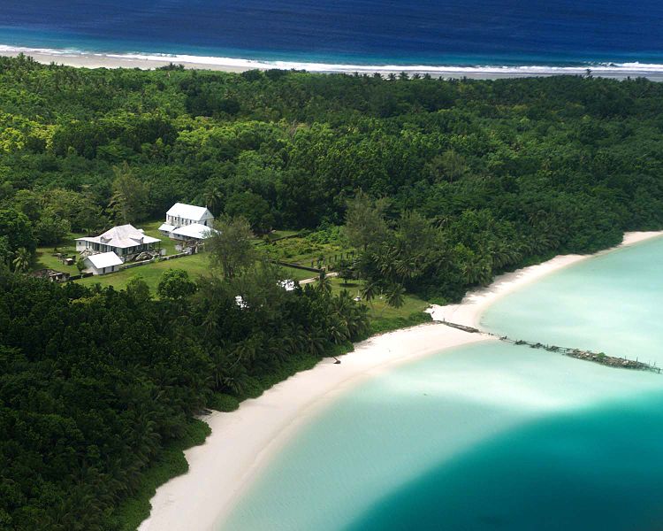
English: Aerial photograph of the coconut plantation at East Point, Diego Garcia. Photograph shows strip of land between both ocean and lagoon.
The island hosts a large airstrip used by the U.S. Armed forces during the Gulf war for operating B-52s. U.S. Submarines and Navy Seal teams have also populated the island in the past. In 1986 The USS Saratoga (CV 60) was docked at the island when it was called away to respond to threats by Lybian Leader Momar Kadaffi and the "Line of Death" in the Gulf of Sidra (also known as the Gulf of Sirte). The carrier left its port while many of its ±4500 sailors were still on the island, which subsequently had to be airlifted via helicopter as the ship made its way to the Mediterranean. The Saratoga spearheaded the assault on the African Nation. |
| Origem | |
| Autor |
Licenciamento
Esta obra encontra-se no domínio público nos Estados Unidos por ser uma obra do Governo Federal dos EUA nos termos do Título 17, Capítulo 1, Secção 105 do US Code. Veja Copyright.
Nota: Este estatuto apenas se aplica a obras do Governo Federal, e não a obras de nenhum estado, condado, subdivisão ou município.
|
 | |
| Este ficheiro foi considerado livre de restrições conhecidas devidas a direitos de autor, incluindo todos os direitos conexos. | ||
Registo de carregamento original
A página de descrição original está aqui. Todos os nomes de utilizador a seguir referem-se a en.wikipedia.
- 2005-12-27 07:37 Jgrimmer 1500×1200×8 (166195 bytes) Ariel photograph of the coconut plantation at East Point, Diego Garcia. Photograph shows stip of land between both ocean and lagoon.
Histórico do ficheiro
Clique uma data e hora para ver o ficheiro tal como ele se encontrava nessa altura.
| Data e hora | Miniatura | Dimensões | Utilizador | Comentário | |
|---|---|---|---|---|---|
| atual | 13h00min de 20 de abril de 2008 | | 1 500 × 1 200 (162 kB) | File Upload Bot (Magnus Manske) | {{BotMoveToCommons|en.wikipedia}} {{Information |Description={{en|Aerial photograph of the coconut plantation at East Point, Diego Garcia. Photograph shows strip of land between both ocean and lagoon. The island hosts a large airstrip used by the U.S. |
Utilização local do ficheiro
As seguintes 2 páginas usam este ficheiro:
Utilização global do ficheiro
As seguintes wikis usam este ficheiro:
- ast.wikipedia.org
- be.wikipedia.org
- ca.wikipedia.org
- ceb.wikipedia.org
- cy.wikipedia.org
- en.wikipedia.org
- eo.wikipedia.org
- es.wikipedia.org
- fa.wikipedia.org
- fr.wikipedia.org
- ga.wikipedia.org
- gl.wikipedia.org
- he.wikipedia.org
- hi.wikipedia.org
- it.wikipedia.org
- mk.wikipedia.org
- ml.wikipedia.org
- mn.wikipedia.org
- ne.wikipedia.org
- nl.wikipedia.org
- no.wikipedia.org
- os.wikipedia.org
- sh.wikipedia.org
- simple.wikipedia.org
- sr.wikipedia.org
- ta.wikipedia.org
- uk.wikipedia.org
- www.wikidata.org
- zh.wikipedia.org