
Ficheiro:Dead Sea Galilee.jpg

Dimensões desta antevisão: 363 × 600 píxeis. Outras resoluções: 145 × 240 píxeis | 290 × 480 píxeis | 465 × 768 píxeis | 1 162 × 1 920 píxeis.
Imagem numa resolução maior (1 162 × 1 920 píxeis, tamanho: 645 kB, tipo MIME: image/jpeg)
|
|
Esta imagem provém do Wikimedia Commons, um acervo de conteúdo livre da Wikimedia Foundation que pode ser utilizado por outros projetos.
|
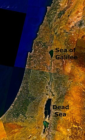
Outdated 1948-1967 geopolitical map depicting Jordanian conquest territory with Dead Sea and the w:Sea of Galilee.
| This image is in the public domain because it is a screenshot from NASA’s globe software World Wind using a public domain layer, such as Blue Marble, MODIS, Landsat, SRTM, USGS or GLOBE.
|
 |
Histórico do ficheiro
Clique uma data e hora para ver o ficheiro tal como ele se encontrava nessa altura.
| Data e hora | Miniatura | Dimensões | Utilizador | Comentário | |
|---|---|---|---|---|---|
| atual | 18h07min de 24 de agosto de 2006 | | 1 162 × 1 920 (645 kB) | Interiot~commonswiki | The Dead Sea and the w:Sea of Galilee. Imagery from NASA World Wind. {{PD-USGov-NASA}} Category:Satellite pictures of IsraelCategory:Satellite pictures of Jordan |
Utilização local do ficheiro
A seguinte página usa este ficheiro:
Utilização global do ficheiro
As seguintes wikis usam este ficheiro:
- bn.wikipedia.org
- ckb.wikipedia.org
- da.wikipedia.org
- el.wiktionary.org
- en.wikipedia.org
- en.wiktionary.org
- fo.wikipedia.org
- fr.wiktionary.org
- fy.wikipedia.org
- id.wikipedia.org
- kn.wikipedia.org
- ku.wikipedia.org
- ml.wikipedia.org
- ms.wikipedia.org
- ro.wikipedia.org
- sc.wikipedia.org
- simple.wikipedia.org
- sl.wikipedia.org
- sw.wikipedia.org
- te.wiktionary.org
- ur.wikipedia.org
- zh.wikipedia.org
- zh.wiktionary.org