
Ficheiro:First Republic of Armenia in 1918-1920.png

Dimensões desta antevisão: 799 × 348 píxeis. Outras resoluções: 320 × 139 píxeis | 640 × 279 píxeis | 1 024 × 446 píxeis | 1 280 × 558 píxeis | 2 560 × 1 115 píxeis | 8 192 × 3 568 píxeis.
Imagem numa resolução maior (8 192 × 3 568 píxeis, tamanho: 14,85 MB, tipo MIME: image/png)
|
|
Esta imagem provém do Wikimedia Commons, um acervo de conteúdo livre da Wikimedia Foundation que pode ser utilizado por outros projetos.
|
Descrição do ficheiro
| Descrição |
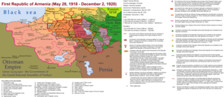
English: The First Republic of Armenia in 1918-1920. |
| Data | |
| Origem | Obra do próprio |
| Autor | Accipite7 |
Licenciamento
Eu, titular dos direitos de autor desta obra, publico-a com a seguinte licença:
A utilização deste ficheiro é regulada nos termos da licença Creative Commons Atribuição-CompartilhaIgual 4.0 Internacional.
- Pode:
- partilhar – copiar, distribuir e transmitir a obra
- recombinar – criar obras derivadas
- De acordo com as seguintes condições:
- atribuição – Tem de fazer a devida atribuição da autoria, fornecer uma hiperligação para a licença e indicar se foram feitas alterações. Pode fazê-lo de qualquer forma razoável, mas não de forma a sugerir que o licenciador o apoia ou subscreve o seu uso da obra.
- partilha nos termos da mesma licença – Se remisturar, transformar ou ampliar o conteúdo, tem de distribuir as suas contribuições com a mesma licença ou uma licença compatível com a original.
Histórico do ficheiro
Clique uma data e hora para ver o ficheiro tal como ele se encontrava nessa altura.
| Data e hora | Miniatura | Dimensões | Utilizador | Comentário | |
|---|---|---|---|---|---|
| atual | 15h13min de 2 de junho de 2021 | | 8 192 × 3 568 (14,85 MB) | Accipite7 | for the convenience of viewing small details, the size is increased, the colors are improved |
| 08h17min de 25 de maio de 2021 |  | 4 096 × 1 784 (3,69 MB) | Accipite7 | The border between Nahang of Shirak and Nahang of Syunik has been clarified. | |
| 09h59min de 21 de maio de 2021 |  | 4 096 × 1 784 (3,7 MB) | Accipite7 | The temporary border between the Republic of Armenia and the Soviet republics (August 10, 1920) in the Nakhichevan county has been clarified. Added a legend marked on the map under the number 26. | |
| 08h35min de 13 de maio de 2021 |  | 4 096 × 1 784 (3,97 MB) | Accipite7 | fixed typo | |
| 08h27min de 13 de maio de 2021 |  | 4 096 × 1 784 (3,97 MB) | Accipite7 | The names of the types of administrative units of the former Russian Empire have been clarified: uyezd = county, okrug = district, oblast = territory, guberniya = governorate. | |
| 11h14min de 12 de maio de 2021 |  | 4 096 × 1 784 (3,71 MB) | Accipite7 | Corrected data in the map legend regarding what is indicated on the map by numbers. Clarified the boundaries of the territories required at the Paris Peace Conference. I strongly ask the user of Culminatio not to vandalize and not return the map to the version on which he marked the line reached as a result of the Turkish offensive in 1920. Since, firstly, it is neural: Batumi, Artvin and Ardahan were under the control of the Democratic Republic of Georgia until February-March 1921. And secon... | |
| 04h13min de 12 de maio de 2021 |  | 5 375 × 2 341 (7,18 MB) | Culminatio | Reverted to version as of 15:05, 8 May 2021 (UTC) | |
| 07h11min de 11 de maio de 2021 |  | 4 096 × 1 784 (3,99 MB) | Accipite7 | The boundaries of the territory of the demands of the Armenian delegation in the Transcaucasus, submitted to the Paris Peace Conference of 1919, were clarified. There is no need to overload the map with the line reached by the Turkish forces in 1920, as the map already shows the results of the Armenian-Turkish war of 1920 - the border according to the Treaty of Alexandropol, December 2, 1920 | |
| 15h05min de 8 de maio de 2021 |  | 5 375 × 2 341 (7,18 MB) | Culminatio | Additional line of the turkish advance on the northern positions during the war of 1920. Additional numbers 10,19,20,21 on the map. | |
| 10h49min de 8 de maio de 2021 |  | 6 336 × 2 760 (2,21 MB) | Accipite7 | Improved colors. |
Utilização local do ficheiro
A seguinte página usa este ficheiro:
Utilização global do ficheiro
As seguintes wikis usam este ficheiro:
- az.wikipedia.org
- be.wikipedia.org
- bg.wikipedia.org
- de.wikipedia.org
- el.wikipedia.org
- fi.wikipedia.org
- fr.wikipedia.org
- hy.wikipedia.org
- it.wikipedia.org
- nl.wikipedia.org
- pl.wikipedia.org
- ro.wikipedia.org
- ru.wikipedia.org
- sr.wikipedia.org
- uk.wikipedia.org
- zh.wikipedia.org