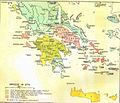
Ficheiro:Greece in 1278.svg

Dimensões desta antevisão em PNG do ficheiro SVG: 800 × 456 píxeis Outras resoluções: 320 × 182 píxeis | 640 × 365 píxeis | 1 024 × 584 píxeis | 1 280 × 730 píxeis | 2 560 × 1 460 píxeis | 3 508 × 2 000 píxeis.
Imagem numa resolução maior (ficheiro SVG, de 3 508 × 2 000 píxeis, tamanho: 1 014 kB)
Histórico do ficheiro
Clique uma data e hora para ver o ficheiro tal como ele se encontrava nessa altura.
| Data e hora | Miniatura | Dimensões | Utilizador | Comentário | |
|---|---|---|---|---|---|
| atual | 20h04min de 23 de junho de 2017 |  | 3 508 × 2 000 (1 014 kB) | Cplakidas | fixed name |
| 12h14min de 11 de abril de 2017 |  | 3 508 × 2 000 (1 017 kB) | Cplakidas | colour changes | |
| 18h22min de 8 de fevereiro de 2017 |  | 3 508 × 2 000 (1 018 kB) | Cplakidas | text to paths | |
| 18h11min de 8 de fevereiro de 2017 |  | 3 508 × 2 000 (1 002 kB) | Cplakidas | User created page with UploadWizard |
Utilização local do ficheiro
As seguintes 3 páginas usam este ficheiro:
Utilização global do ficheiro
As seguintes wikis usam este ficheiro:
- ar.wikipedia.org
- az.wikipedia.org
- bg.wikipedia.org
- el.wikipedia.org
- en.wikipedia.org
- Fourth Crusade
- Principality of Achaea
- Patras
- Portal:Spain
- Battle of Halmyros
- History of Thessaly
- John I Doukas of Thessaly
- Nicholas III of Saint-Omer
- Nicholas II of Saint-Omer
- Matilda of Hainaut
- Boniface of Verona
- Battle of Neopatras
- Battle of Demetrias
- Lordship of Salona
- Jacopo Dondulo
- Byzantine–Venetian treaty of 1277
- es.wikipedia.org
- et.wikipedia.org
- fa.wikipedia.org
- fr.wikipedia.org
- hr.wikipedia.org
- hyw.wikipedia.org
- it.wikipedia.org
- ka.wikipedia.org
- pl.wikipedia.org
- ru.wikipedia.org
- sq.wikipedia.org
- sr.wikipedia.org
- tr.wikipedia.org
- uk.wikipedia.org
- www.wikidata.org
Ver mais utilizações globais deste ficheiro.


