
Ficheiro:High Asia Mountain Ranges.jpg

Dimensões desta antevisão: 763 × 600 píxeis. Outras resoluções: 306 × 240 píxeis | 611 × 480 píxeis | 978 × 768 píxeis | 1 280 × 1 006 píxeis | 2 560 × 2 011 píxeis | 5 600 × 4 400 píxeis.
Imagem numa resolução maior (5 600 × 4 400 píxeis, tamanho: 10,79 MB, tipo MIME: image/jpeg)
|
|
Esta imagem provém do Wikimedia Commons, um acervo de conteúdo livre da Wikimedia Foundation que pode ser utilizado por outros projetos.
|
Descrição do ficheiro
| Descrição |
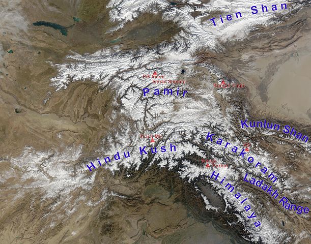
English: high Asian mountain ranges and their highest mountains:
Deutsch: Die innerasiatischen Hochgebirge:
|
| Data | (UTC) |
| Origem |
Este ficheiro foi derivado de: Hindu Kush satellite image.jpg: |
| Autor |
|
| Esta é uma imagem retocada, o que significa que a versão original foi alterada digitalmente. Modificações: mountain ranges (and highest mountains) labelled. O original pode ser visto aqui: Hindu Kush satellite image.jpg:
|
Licenciamento
| Este ficheiro está no domínio público nos Estados Unidos porque foi criado exclusivamente pela NASA. As orientações sobre o direito de autor da NASA são que «as obras da NASA não têm os direitos de autor protegidos salvo indicação em contrário». Veja Template:PD-USGov, as orientações sobre o direito de autor da NASA ou as normas de uso de imagens do Laboratório de Propulsão a Jato (Jet Propulsion Lab, JPL). | ||
 |
Avisos:
|
Registo de carregamento original
This image is a derivative work of the following images:
- File:Hindu_Kush_satellite_image.jpg licensed with PD-USGov-NASA
- 2006-06-06T04:39:19Z Avenue 5600x4400 (5255682 Bytes) {{Information |Description=The Hindu Kush occupies the lower-left-center of this true-color MODIS satellite image, acquired 28 November 2003. |Source=[NASA's Earth Observatory http://earthobservatory.nasa.gov/Newsroom/NewImag
Carregada com derivativeFX
Histórico do ficheiro
Clique uma data e hora para ver o ficheiro tal como ele se encontrava nessa altura.
| Data e hora | Miniatura | Dimensões | Utilizador | Comentário | |
|---|---|---|---|---|---|
| atual | 13h05min de 27 de novembro de 2012 | | 5 600 × 4 400 (10,79 MB) | Rupert Pupkin | ladakh range added |
| 11h15min de 27 de novembro de 2012 |  | 5 600 × 4 400 (10,71 MB) | Rupert Pupkin | == {{int:filedesc}} == {{Information |Description=The Hindu Kush occupies the lower-left-center of this true-color MODIS satellite image, acquired 28 November 2003. |Source={{Derived from|Hindu_Kush_satellite_image.jpg|display=50}} |Date=2012-11-27 11:... |
Utilização local do ficheiro
A seguinte página usa este ficheiro:
Utilização global do ficheiro
As seguintes wikis usam este ficheiro:
- af.wikipedia.org
- ba.wikipedia.org
- bcl.wikipedia.org
- bn.wikipedia.org
- ceb.wikipedia.org
- de.wikipedia.org
- en.wikipedia.org
- en.wikivoyage.org
- es.wikipedia.org
- eu.wikipedia.org
- fa.wikipedia.org
- fa.wikivoyage.org
- fr.wikipedia.org
- hy.wikipedia.org
- id.wikipedia.org
- it.wikipedia.org
- lt.wikipedia.org
- ms.wikipedia.org
- nl.wikipedia.org
- pl.wikipedia.org
- pnb.wikipedia.org
- ru.wikipedia.org
- sco.wikipedia.org
- sd.wikipedia.org
- simple.wikipedia.org
- sl.wikipedia.org
- sv.wikipedia.org
- ta.wikipedia.org
Ver mais utilizações globais deste ficheiro.