
Ficheiro:Katrina–Victor–Cindy 1998 track.png

Dimensões desta antevisão: 800 × 495 píxeis. Outras resoluções: 320 × 198 píxeis | 640 × 396 píxeis | 1 024 × 633 píxeis | 1 280 × 791 píxeis | 2 700 × 1 669 píxeis.
Imagem numa resolução maior (2 700 × 1 669 píxeis, tamanho: 1,77 MB, tipo MIME: image/png)
|
|
Esta imagem provém do Wikimedia Commons, um acervo de conteúdo livre da Wikimedia Foundation que pode ser utilizado por outros projetos.
|
| Descrição |
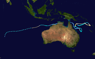
English: Track map of Severe Tropical Cyclone Katrina–Victor–Cindy of the 1997–98 Australian region, South Pacific and South-West Indian Ocean cyclone seasons. The points show the location of the storm at 6-hour intervals. The colour represents the storm's maximum sustained wind speeds as classified in the Saffir-Simpson Hurricane Scale (see below), and the shape of the data points represent the nature of the storm, according to the legend below. |
| Data | |
| Origem | Created using Wikipedia:WikiProject Tropical cyclones/Tracks. The background image is from NASA. Tracking data is from JTWC (Katrina & Victor–Cindy). |
| Autor | Meow |
| Outras versões |
|


| Eu, titular dos direitos de autor desta obra, dedico-a ao domínio público, com aplicação em todo o mundo. Nalguns países isto pode não ser legalmente possível; se assim for: Concedo a todos o direito de usar esta obra para qualquer fim, sem quaisquer condições, a menos que tais condições sejam impostas por lei. |
Histórico do ficheiro
Clique uma data e hora para ver o ficheiro tal como ele se encontrava nessa altura.
| Data e hora | Miniatura | Dimensões | Utilizador | Comentário | |
|---|---|---|---|---|---|
| atual | 01h33min de 22 de julho de 2014 | | 2 700 × 1 669 (1,77 MB) | Meow | User created page with UploadWizard |
Utilização local do ficheiro
A seguinte página usa este ficheiro:
Utilização global do ficheiro
As seguintes wikis usam este ficheiro:
- en.wikipedia.org