
Ficheiro:Kuwaiti islands.jpg

Dimensões desta antevisão: 667 × 600 píxeis. Outras resoluções: 267 × 240 píxeis | 534 × 480 píxeis | 854 × 768 píxeis | 1 139 × 1 024 píxeis | 2 277 × 2 048 píxeis | 4 242 × 3 815 píxeis.
Imagem numa resolução maior (4 242 × 3 815 píxeis, tamanho: 5,39 MB, tipo MIME: image/jpeg)
|
|
Esta imagem provém do Wikimedia Commons, um acervo de conteúdo livre da Wikimedia Foundation que pode ser utilizado por outros projetos.
|
Descrição do ficheiro
| Kuwaiti islands | |
|---|---|
| Fotógrafo |
Envisat satellite |
| Título |
Kuwaiti islands |
| Descrição |
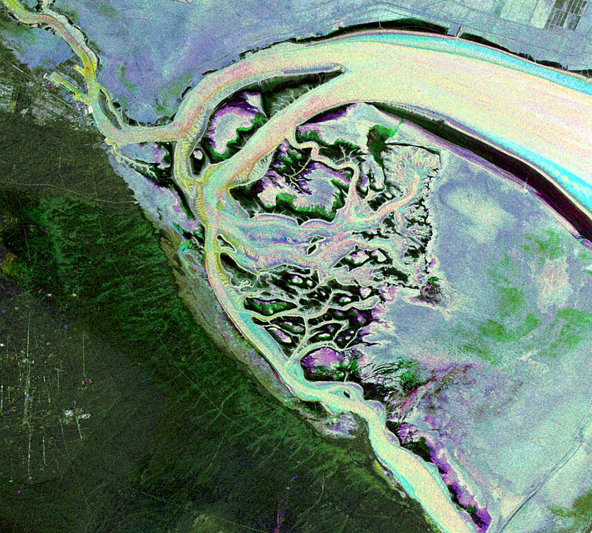
English: This Envisat image features the Kuwait islands of Warbah and Bubiyan, located at the head of the Persian Gulf.
What appears to be water across the top and right side of the image (lilac, green and blue) is land. The brighter yellow, aqua and pink colours represent water. Here, the water currents in these channels can be observed thanks to the radar imagery as they flow out into the gulf. The image was created by combining three Advanced Synthetic Aperture Radar (ASAR) acquisitions (22 August 2009, 26 September 2009 and 31 October 2009) taken over the same area. The colours in the image result from variations in the surface that occurred between acquisitions. |
| Lugar retratado | Kuwait |
| Data | entre 22 de agosto de 2009 e 31 de outubro de 2009 |
| Coleção | European Space Agency |
| Número de inventário |
236846 |
| Modo de aquisição | ESA |
| Origem | http://www.esa.int/spaceinimages/Images/2010/02/Kuwaiti_islands |
Licenciamento
A utilização deste ficheiro é regulada nos termos da licença Creative Commons Atribuição-CompartilhaIgual 3.0 OIG.
- Pode:
- partilhar – copiar, distribuir e transmitir a obra
- recombinar – criar obras derivadas
- De acordo com as seguintes condições:
- atribuição – Tem de fazer a devida atribuição da autoria, fornecer uma hiperligação para a licença e indicar se foram feitas alterações. Pode fazê-lo de qualquer forma razoável, mas não de forma a sugerir que o licenciador o apoia ou subscreve o seu uso da obra.
- partilha nos termos da mesma licença – Se remisturar, transformar ou ampliar o conteúdo, tem de distribuir as suas contribuições com a mesma licença ou uma licença compatível com a original.
Histórico do ficheiro
Clique uma data e hora para ver o ficheiro tal como ele se encontrava nessa altura.
| Data e hora | Miniatura | Dimensões | Utilizador | Comentário | |
|---|---|---|---|---|---|
| atual | 07h12min de 27 de fevereiro de 2017 | | 4 242 × 3 815 (5,39 MB) | Revent | =={{int:filedesc}}== {{Photograph |photographer = Envisat satellite |title = Kuwaiti islands |description = {{en|1=This Envisat image features the Kuwait islands of Warbah and Bubiyan, located at the head of the Persian Gul... |
Utilização local do ficheiro
A seguinte página usa este ficheiro:
Utilização global do ficheiro
As seguintes wikis usam este ficheiro:
- cs.wikipedia.org
- de.wikipedia.org
- en.wikipedia.org
- es.wikipedia.org
- fr.wikipedia.org
- uk.wikipedia.org