
Ficheiro:Lake Tiberias (Sea of Galilee), Northern Israel.jpg
Dimensões desta antevisão: 398 × 599 píxeis. Outras resoluções: 159 × 240 píxeis | 319 × 480 píxeis | 510 × 768 píxeis | 680 × 1 024 píxeis | 1 440 × 2 168 píxeis.
Imagem numa resolução maior (1 440 × 2 168 píxeis, tamanho: 1,15 MB, tipo MIME: image/jpeg)
|
|
Esta imagem provém do Wikimedia Commons, um acervo de conteúdo livre da Wikimedia Foundation que pode ser utilizado por outros projetos.
|
,_Northern_Israel.jpg)
Descrição do ficheiro
| Descrição |
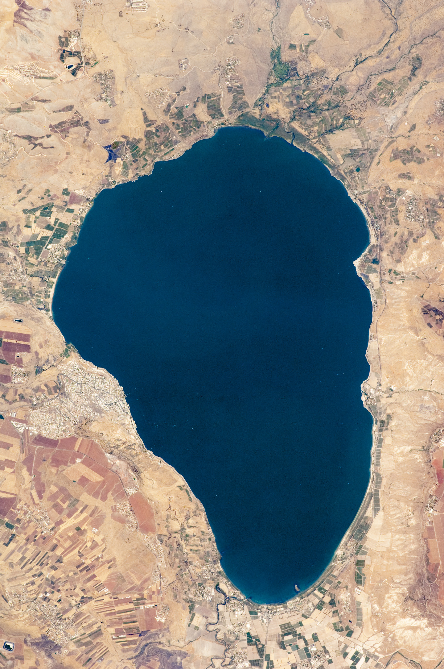
English: Israel’s largest freshwater lake, Lake Tiberias, is also known as the Sea of Tiberias, Lake of Gennesaret, Lake Kinneret, and the Sea of Galilee. The lake measures just more than 21 kilometres north-south, and it is only 43 meters deep. The lake is fed partly by underground springs related to the Jordan sector of the Great Rift Valley, but most of its water comes from the Jordan River, which enters from the north. The river’s winding course can be seen draining the south end of the lake at image bottom. Angular green and brown field patterns clothe most hillsides in this arid landscape. Bright roof tops are the hallmark of several villages in the area. The largest grouping of bright roofs and city blocks indicates the location of Tiberias (named for the Roman Emperor Tiberius), visible at image left on the south-western shore of the lake.
|
||||||||||||||||||||||||||||||||||||||||||||||||||
| Data | |||||||||||||||||||||||||||||||||||||||||||||||||||
| Origem | NASA Earth Observatory | ||||||||||||||||||||||||||||||||||||||||||||||||||
| Autor | This image was taken by the NASA Expedition 20 crew. | ||||||||||||||||||||||||||||||||||||||||||||||||||
| Outras versões | Obras derivadas deste ficheiro: (Sea of Galilee Northern Israel-2.jpg | ||||||||||||||||||||||||||||||||||||||||||||||||||
Image acquired with a Nikon D2Xs digital camera fitted with an 400 mm lens, and is provided by the ISS Crew Earth Observations experiment and Image Science & Analysis Laboratory, Johnson Space Centre.
Licenciamento
| Este ficheiro está no domínio público nos Estados Unidos porque foi criado exclusivamente pela NASA. As orientações sobre o direito de autor da NASA são que «as obras da NASA não têm os direitos de autor protegidos salvo indicação em contrário». Veja Template:PD-USGov, as orientações sobre o direito de autor da NASA ou as normas de uso de imagens do Laboratório de Propulsão a Jato (Jet Propulsion Lab, JPL). | ||
 |
Avisos:
|
Histórico do ficheiro
Clique uma data e hora para ver o ficheiro tal como ele se encontrava nessa altura.
| Data e hora | Miniatura | Dimensões | Utilizador | Comentário | |
|---|---|---|---|---|---|
| atual | 11h32min de 14 de setembro de 2009 | | 1 440 × 2 168 (1,15 MB) | Originalwana | {{Information |Description={{en|1=Israel’s largest freshwater lake, Lake Tiberias, is also known as the Sea of Tiberias, Lake of Gennesaret, Lake Kinneret, and the Sea of Galilee. The lake measures just more than 21 kilometres north-south, and it is |
Utilização local do ficheiro
A seguinte página usa este ficheiro:
Utilização global do ficheiro
As seguintes wikis usam este ficheiro:
- af.wikipedia.org
- ar.wikipedia.org
- bn.wikipedia.org
- br.wikipedia.org
- ceb.wikipedia.org
- cy.wikipedia.org
- de.wikipedia.org
- el.wikipedia.org
- en.wikipedia.org
- en.wikivoyage.org
- eo.wikipedia.org
- es.wikipedia.org
- eu.wikipedia.org
- fy.wikipedia.org
- ga.wikipedia.org
- he.wikipedia.org
- ויקיפדיה:תמונה מומלצת/המלצות קודמות/יולי 2012
- ויקיפדיה:תמונה מומלצת/הוספה למומלצים/ארכיון 40
- תבנית:תמונה מומלצת 23 ביולי 2012
- ויקיפדיה:ערכים מומלצים/המלצות קודמות/יולי 2013
- פורטל:ערכים מומלצים/ערכים/הכנרת
- תבנית:ערך מומלץ 1 ביולי 2013
- תבנית:ערך מומלץ 2 ביולי 2013
- ויקיפדיה:ערכים מומלצים/המלצות קודמות/פברואר 2018
- תבנית:ערך מומלץ 11 בפברואר 2018
- תבנית:ערך מומלץ 12 בפברואר 2018
- he.wikivoyage.org
- hy.wikipedia.org
- ia.wikipedia.org
- id.wikipedia.org
Ver mais utilizações globais deste ficheiro.
,_Northern_Israel.jpg)
,_Northern_Israel.jpg)