
Ficheiro:Map of Slave Coast-1789.jpg

Dimensões desta antevisão: 800 × 479 píxeis. Outras resoluções: 320 × 191 píxeis | 640 × 383 píxeis | 1 024 × 613 píxeis | 1 280 × 766 píxeis | 3 157 × 1 889 píxeis.
Imagem numa resolução maior (3 157 × 1 889 píxeis, tamanho: 2,45 MB, tipo MIME: image/jpeg)
|
|
Esta imagem provém do Wikimedia Commons, um acervo de conteúdo livre da Wikimedia Foundation que pode ser utilizado por outros projetos.
|
| Descrição |
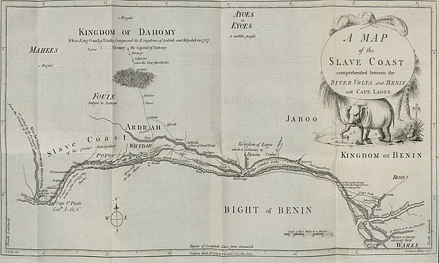
English: Map of the Slave Coast published in Memoirs of the Reign of Bossa Ahádee, King of Dahomy, an Inland Country of Guiney. To Which Are Added, the Author's Journey to Abomey, the Capital; and a Short Account of the African Slave Trade by British slave trader Robert Norris in 1789. |
| Data | |
| Origem | http://dcc.newberry.org/collections/olaudah-equiano |
| Autor | Norris, Robert |
|
Esta obra está no domínio público no seu país de origem e noutros países e áreas onde o período de proteção dos direitos de autor é igual ou inferior à vida do autor mais 100 anos. | |
| Este ficheiro foi considerado livre de restrições conhecidas devidas a direitos de autor, incluindo todos os direitos conexos. | |
Histórico do ficheiro
Clique uma data e hora para ver o ficheiro tal como ele se encontrava nessa altura.
| Data e hora | Miniatura | Dimensões | Utilizador | Comentário | |
|---|---|---|---|---|---|
| atual | 11h29min de 18 de julho de 2015 | | 3 157 × 1 889 (2,45 MB) | Lubiesque | Better copy |
| 23h59min de 17 de julho de 2015 |  | 5 261 × 3 148 (2 MB) | Lubiesque | Better copy. High resolution | |
| 18h48min de 15 de abril de 2010 |  | 957 × 481 (233 kB) | Ji-Elle | {{Information |Description={{en|Map of the Slave Coast}} |Source=Gallica [http://gallica.bnf.fr/ark:/12148/bpt6k1057573.image.r=abomey.f3.langFR] from ''Memoirs of the reign of Bossa Ahádee, king of Dahomy, an inland country of Guiney ; to which are add |
Utilização local do ficheiro
A seguinte página usa este ficheiro: