
Ficheiro:Map of tropical cyclone affected areas.png

Dimensões desta antevisão: 800 × 371 píxeis. Outras resoluções: 320 × 148 píxeis | 640 × 296 píxeis | 1 347 × 624 píxeis.
Imagem numa resolução maior (1 347 × 624 píxeis, tamanho: 94 kB, tipo MIME: image/png)
|
|
Esta imagem provém do Wikimedia Commons, um acervo de conteúdo livre da Wikimedia Foundation que pode ser utilizado por outros projetos.
|
| Descrição |
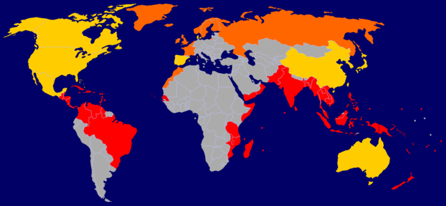
A map of tropical cyclone affected areas. Based off Image:BlankMap-World-v5.png and overlaid with Image:Ocean-layer BlankMap-World.png. Information based mainly off Image:Global tropical cyclone tracks.jpg. Fully-tropical cyclones have affected these nations/territories.
Both fully-tropical cyclones, as well as extratropical remnants of tropical cyclones, have affected these areas.
Extratropical remnants of tropical cyclones have affected these areas.
This is by no means a fully-complete map, and may contain errors. |
||||||||
| Data |
2006-09-29 Updated: 2006-09-30 Updated: 2006-12-23 Updated: 2007-04-09 |
||||||||
| Origem | Self-work | ||||||||
| Autor | User:NSLE-Chacor | ||||||||
| Permissão (Reutilizar este ficheiro) |
|

Histórico do ficheiro
Clique uma data e hora para ver o ficheiro tal como ele se encontrava nessa altura.
| Data e hora | Miniatura | Dimensões | Utilizador | Comentário | |
|---|---|---|---|---|---|
| atual | 16h08min de 9 de abril de 2007 | | 1 347 × 624 (94 kB) | NSLE-Chacor | Background changed to blue, Panama back to red |
| 12h19min de 23 de dezembro de 2006 |  | 1 347 × 624 (93 kB) | NSLE-Chacor | Further update using Image:Global tropical cyclone tracks.jpg - two countries changed to grey (unaffected), Senegal added in tropical | |
| 12h08min de 23 de dezembro de 2006 |  | 1 347 × 624 (93 kB) | NSLE-Chacor | Fixed stray blues not changed in colour scheme change | |
| 12h06min de 23 de dezembro de 2006 |  | 1 347 × 624 (93 kB) | NSLE-Chacor | update: Colour change, Mexico, Bahamas and Taiwan to both tropical and extratropical | |
| 05h04min de 30 de setembro de 2006 |  | 1 347 × 624 (130 kB) | NSLE-Chacor | Update: Denmark changed to green (Faeroe Islands affected by w:Hurricane Faith while tropical); Australia changed to green (extratropical remnants recorded). | |
| 06h15min de 29 de setembro de 2006 |  | 1 347 × 624 (130 kB) | NSLE-Chacor | {{Information |Description= A map of tropical cyclone affected areas. Based off Image:BlankMap-World-v5.png and overlaid with Image:Ocean-layer BlankMap-World.png. Aqua-coloured nations/territories indicate that fully-tropical cyclones have affe |
Utilização local do ficheiro
As seguintes 2 páginas usam este ficheiro:
Utilização global do ficheiro
As seguintes wikis usam este ficheiro:
- el.wikipedia.org
- en.wikipedia.org
- ml.wikipedia.org