
Ficheiro:Mexico-2669 - Palenque (2213894589).jpg
Imagem numa resolução maior (3 308 × 2 506 píxeis, tamanho: 7,78 MB, tipo MIME: image/jpeg)
|
|
Esta imagem provém do Wikimedia Commons, um acervo de conteúdo livre da Wikimedia Foundation que pode ser utilizado por outros projetos.
|
.jpg)
Descrição do ficheiro
| Descrição |
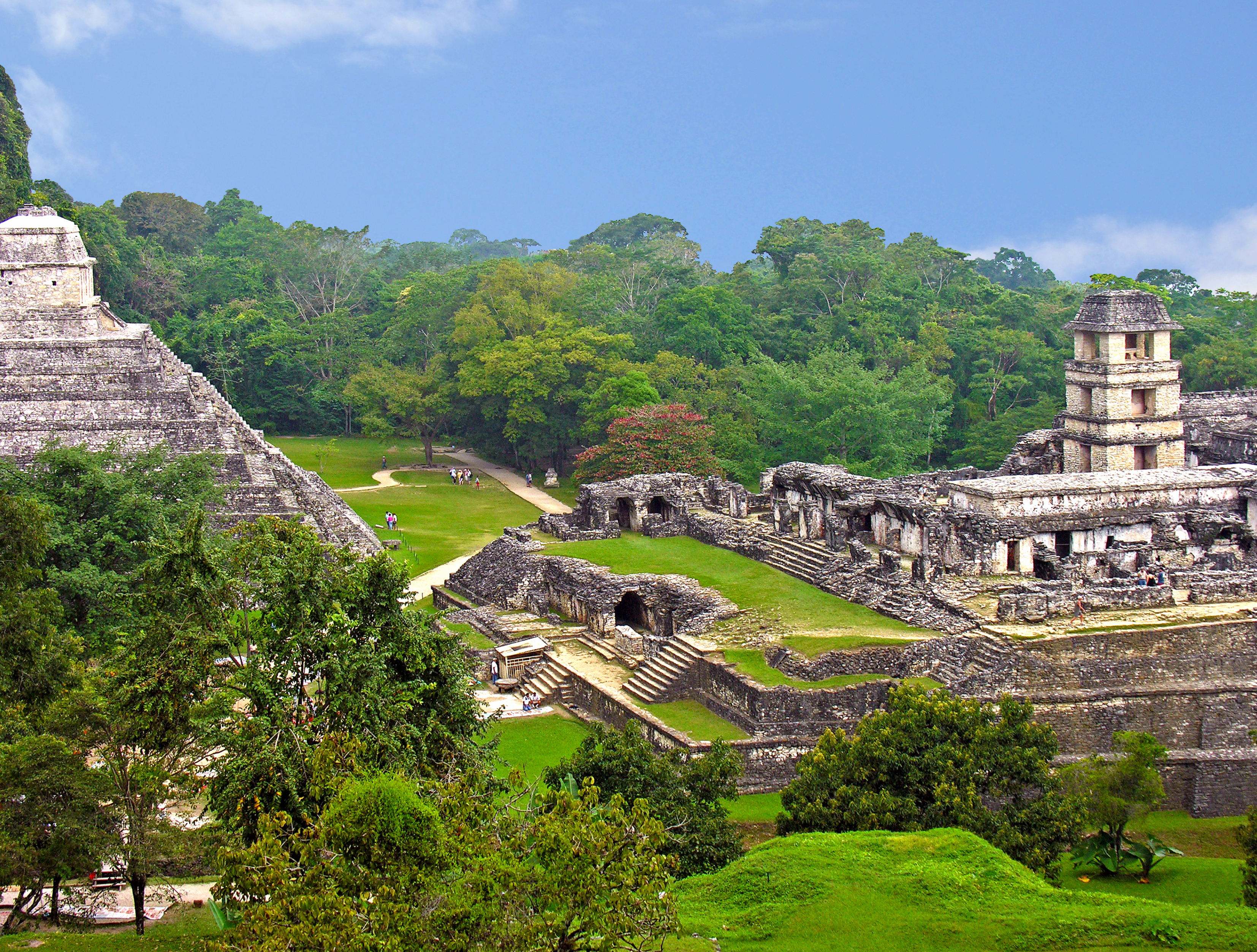
English: The Mayan site of Palenque - View from the Temple of the Cross, Palace complex to the right and Temple of Inscriptions to the left.
Palenque is a Spanish word for "fortification". An ancient name for the city was Lakam Ha, which translates as "Great Water", for the springs and small rivers which flow from the site. Palenque is definitely one of the most beautiful sites in all of Mesoamerica. The richest and most elaborate tomb ever discovered in Mexico is located in the Temple of Inscriptions at Palenque. Lord Pakal's tomb is now closed as is the Temple of Inscriptions. The first permanent settlement of Palenque was about 300 AD. The apex of Maya civilization begins about 600 AD. During the next hundred years, the rulers of Palenque commissioned some of the best Maya artwork discovered. Most of the great structures in Palenque's central area date from this time period. These works were built by the two greatest Palenque rulers, K'inich Janaab' Pakal I and his oldest son, K’inich Kan B’alam II. After 731 AD. most construction had stopped. Unfortunately, Palenque's best known 8th century ruler, K'inich K'an Joy Chitam II, is famous only for his defeat and capture in 711 AD by the new military power of Tonina. By 810 AD. the ritual activity in Palenque comes to an end. Then by 900 AD. Palenque becomes deserted and reclaimed by the forest. |
| Data | |
| Origem | Mexico-2669 - Palenque |
| Autor | Dennis Jarvis from Halifax, Canada |
| Localização da câmara | | Esta e outras imagens nas suas localizações em: OpenStreetMap |
|---|
.jpg¶ms=017.376852_N_-091.996765_E_globe:Earth_type:camera_source:Flickr_&language=pt)
Licenciamento
- Pode:
- partilhar – copiar, distribuir e transmitir a obra
- recombinar – criar obras derivadas
- De acordo com as seguintes condições:
- atribuição – Tem de fazer a devida atribuição da autoria, fornecer uma hiperligação para a licença e indicar se foram feitas alterações. Pode fazê-lo de qualquer forma razoável, mas não de forma a sugerir que o licenciador o apoia ou subscreve o seu uso da obra.
- partilha nos termos da mesma licença – Se remisturar, transformar ou ampliar o conteúdo, tem de distribuir as suas contribuições com a mesma licença ou uma licença compatível com a original.
| Esta imagem foi originalmente carregada no Flickr por archer10 (Dennis) REPOSTING em https://www.flickr.com/photos/22490717@N02/2213894589. Ela foi revisada em 28 de maio de 2015 pelo robô FlickreviewR, que confirmou o licenciamento da imagem sob os termos de cc-by-sa-2.0. |
Histórico do ficheiro
Clique uma data e hora para ver o ficheiro tal como ele se encontrava nessa altura.
| Data e hora | Miniatura | Dimensões | Utilizador | Comentário | |
|---|---|---|---|---|---|
| atual | 16h28min de 28 de maio de 2015 | | 3 308 × 2 506 (7,78 MB) | Wilfredor | Transferred from Flickr via Flickr2Commons |
Utilização local do ficheiro
A seguinte página usa este ficheiro:
Utilização global do ficheiro
As seguintes wikis usam este ficheiro:
- en.wikibooks.org
- es.wikipedia.org
- ko.wikipedia.org
.jpg)