
Ficheiro:Mtcook.nz.750pix.jpg
Imagem numa resolução maior (6 108 × 5 637 píxeis, tamanho: 4,66 MB, tipo MIME: image/jpeg)
|
|
Esta imagem provém do Wikimedia Commons, um acervo de conteúdo livre da Wikimedia Foundation que pode ser utilizado por outros projetos.
|
Descrição do ficheiro
| Descrição |
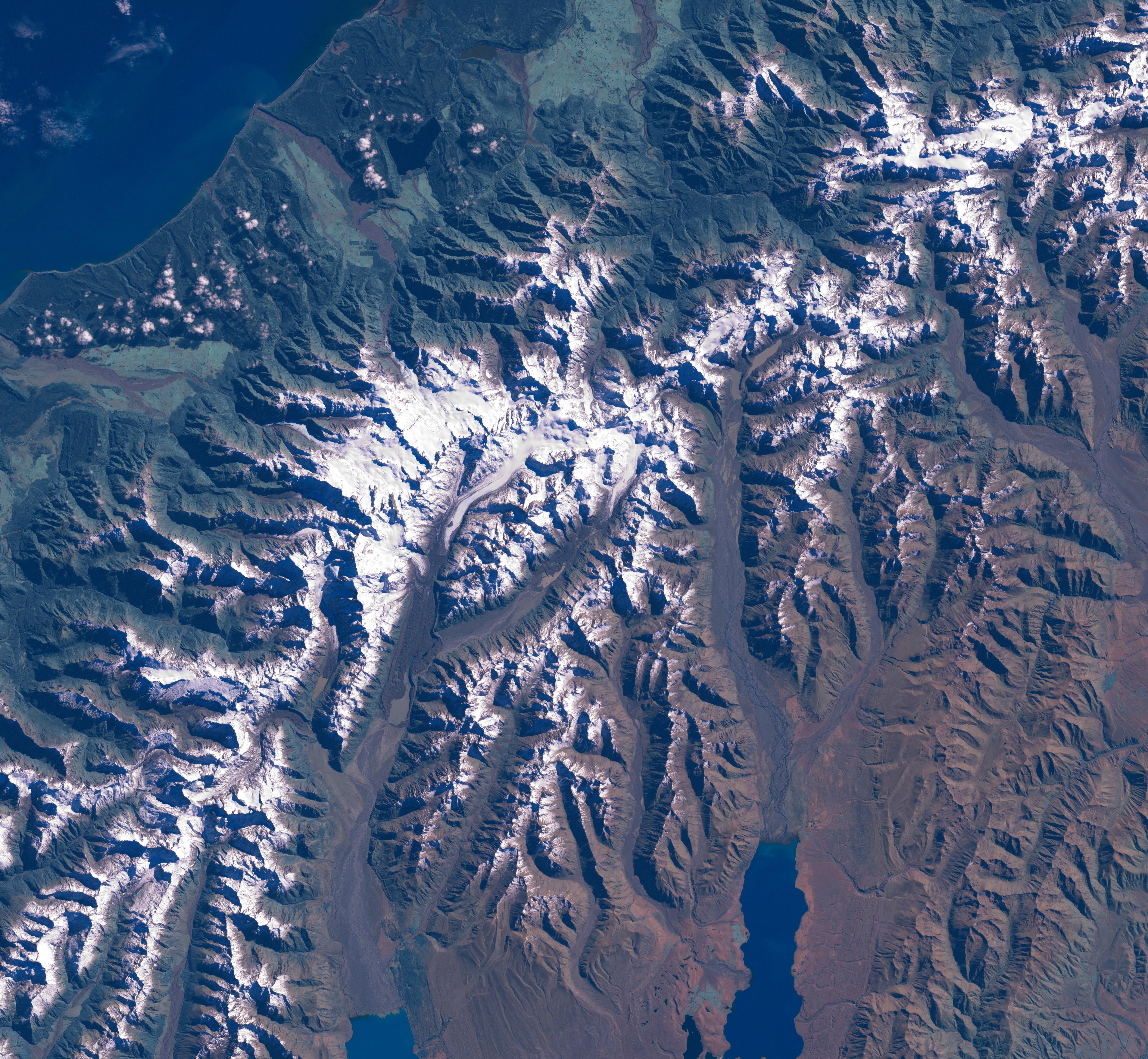
The Aoraki/Mount Cook area from LandSat. This image was acquired by Landsat 7's Enhanced Thematic Mapper plus (ETM ) sensor on March 31, 2001. This is a true-color image made using red, green, and blue wavelengths (ETM bands 3, 2, and 1). The image has also been pan-sharpened to heighten the details and resolution. |
| Origem |
SOURCE:
http://earthobservatory.nasa.gov/Newsroom/NewImages/images.php3?img_id=15331
This image was acquired by Landsat 7's Enhanced Thematic Mapper plus (ETM ) sensor on March 31, 2001. This is a true-color image made using red, green, and blue wavelengths (ETM bands 3, 2, and 1). The image has also been pan-sharpened to heighten the details and resolution. ”The purpose of NASA's Earth Observatory is to provide a freely-accessible publication on the Internet where the public can obtain new satellite imagery and scientific information about our home planet. The focus is on Earth's climate and environmental change. In particular, we hope our site is useful to public media and educators. Any and all materials published on the Earth Observatory are freely available for re-publication or re-use, except where copyright is indicated. We ask that NASA's Earth Observatory be given credit for its original materials.” |
| Autor | Picture prepared for Wikipedia by Adrian Pingstone in November 2003. |
| Permissão (Reutilizar este ficheiro) |
PD |
Original authors
- Source: en.wikipedia.org
- Upload Tool Operator: Flominator (Flominator)
- Image contributor(s): Arpingstone
- 17:49, 7 November 2003 Arpingstone 750×750 (116,804 bytes) (Mount Cook from LandSat)
Licenciamento
| Este ficheiro está no domínio público nos Estados Unidos porque foi criado exclusivamente pela NASA. As orientações sobre o direito de autor da NASA são que «as obras da NASA não têm os direitos de autor protegidos salvo indicação em contrário». Veja Template:PD-USGov, as orientações sobre o direito de autor da NASA ou as normas de uso de imagens do Laboratório de Propulsão a Jato (Jet Propulsion Lab, JPL). | ||
 |
Avisos:
|
Histórico do ficheiro
Clique uma data e hora para ver o ficheiro tal como ele se encontrava nessa altura.
| Data e hora | Miniatura | Dimensões | Utilizador | Comentário | |
|---|---|---|---|---|---|
| atual | 16h20min de 24 de fevereiro de 2007 | | 6 108 × 5 637 (4,66 MB) | Tom | higher res and w/o english words |
| 08h32min de 29 de agosto de 2006 |  | 750 × 750 (114 kB) | CommonismNow | {{Information| |Description=This image was acquired by Landsat 7's Enhanced Thematic Mapper plus (ETM ) sensor on March 31, 2001. This is a true-color image made using red, green, and blue wavelengths (ETM bands 3, 2, and 1). The image has also been pan- |
Utilização local do ficheiro
A seguinte página usa este ficheiro:
Utilização global do ficheiro
As seguintes wikis usam este ficheiro:
- ar.wikipedia.org
- bg.wikipedia.org
- bn.wikipedia.org
- ca.wikipedia.org
- cy.wikipedia.org
- da.wikipedia.org
- de.wikipedia.org
- en.wikipedia.org
- es.wikipedia.org
- eu.wikipedia.org
- hr.wikipedia.org
- ja.wikipedia.org
- mt.wikipedia.org
- nn.wikipedia.org
- sh.wikipedia.org
- sl.wikipedia.org