Ficheiro:Notre-Dame de Paris composite transverse section.svg

O conteúdo da página não é suportado noutras línguas.
Origem: Wikipédia, a enciclopédia livre.

Imagem numa resolução maior(ficheiro SVG, de 856 × 1 494 píxeis, tamanho: 407 kB)

Descrição do ficheiro

Descrição
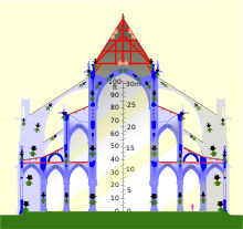
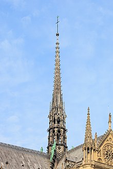
English: Composite transverse section of Notre-Dame de Paris before the 2019 fire. Timber framework in red, masonry in blues, metal in grey. Left, a tower, showing internal framework of belfry (bells not shown). Center, nave, covered by masonry vault and 55-degree triangular roof (spire shown above and behind). Right, side aisles, triforium aisle above, flying buttresses. Note that the vaults thrust outwards on the walls, and the flying buttresses thrust inwards; unless these two forces balance, the wall will be pushed over. Black arrows show the force of the weight of the structure being transmitted to the ground; green arrows show the upwards force of the ground supporting the structure. Orange and grey arrows show the forces in the wood and metal of the roof trusses. Roof trusses cancel out their outwards forces using internal tension (masonry cannot support tension). Light added for clarity.
Data
Origem Own work, derived as indicated under "authors"
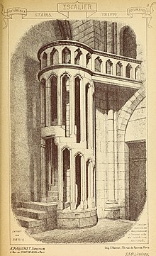
Autor Own work, traced from public domain File:Notre Dame 531 transverse crop rot.jpg and heavily altered, mostly using the public domain architectural drawings of Eugène Viollet-le-Duc (see particularly Category:Frame of Notre-Dame de Paris). The public-domain image File:Materials and documents of architecture and sculpture - classified alphabetically (1915) (14587788087).jpg was used for the stair. Photos were also used to verify details; thanks to all Commons contributors who took unconventional shots.
Outras versões
non-composite cross-section
Localização da câmara 48° 51′ 10,8″ N, 2° 20′ 59,28″ E  Heading=135° Kartographer map based on OpenStreetMap.Esta e outras imagens nas suas localizações em: OpenStreetMapinfo

Please note that this is not a finite element analysis, nor yet an architectural drawing; it's an infographic. That said, corrections are welcome. There are probably errors; I honestly have no good data on the space between the the vaults and the floors, for instance, and no idea if the area between the towers is even flat. I've made guesses, which I hope are sensible ones. The crypt, foundations, and staircase in the belfry framing are not shows due to lack of data. The North tower is shown with the framing of the south tower, due to a lack of an elevation of the latter. There are eight bells in the north tower, but from this perspective four bells are hiding behind the other four. I do not know which bells are larger and have not attempted to show the size range.

Licenciamento

w:pt:Creative Commons
atribuição partilha nos termos da mesma licença
A utilização deste ficheiro é regulada nos termos da licença Creative Commons Atribuição-CompartilhaIgual 4.0 Internacional.
Pode:
  • partilhar – copiar, distribuir e transmitir a obra
  • recombinar – criar obras derivadas
De acordo com as seguintes condições:
  • atribuição – Tem de fazer a devida atribuição da autoria, fornecer uma hiperligação para a licença e indicar se foram feitas alterações. Pode fazê-lo de qualquer forma razoável, mas não de forma a sugerir que o licenciador o apoia ou subscreve o seu uso da obra.
  • partilha nos termos da mesma licença – Se remisturar, transformar ou ampliar o conteúdo, tem de distribuir as suas contribuições com a mesma licença ou uma licença compatível com a original.
Anotações
InfoField
Esta imagem está anotada: Ver as anotações na wiki Commons

Legendas

Adicione uma explicação de uma linha do que este ficheiro representa
Composite transverse section of Notre-Dame de Paris

Elementos retratados neste ficheiro

retrata

48°51'10.8"N, 2°20'59.3"E

image/svg+xml

Histórico do ficheiro

Clique uma data e hora para ver o ficheiro tal como ele se encontrava nessa altura.

Data e horaMiniaturaDimensõesUtilizadorComentário
atual01h30min de 6 de março de 2020Miniatura da versão das 01h30min de 6 de março de 2020856 × 1 494 (407 kB)HLHJPut the rafters of the tower in compression. Not sure how I missed that.
01h49min de 30 de julho de 2019Miniatura da versão das 01h49min de 30 de julho de 2019856 × 1 494 (408 kB)HLHJBells roughed in, positions researched from [https://www.nytimes.com/interactive/2019/07/16/world/europe/notre-dame.html NYT infographic model]. Note that the framework shown for the North Tower is that of the South Tower, as no elevation drawing of the north belltower framework seems to be available on Commons (please let me know if you find one).
17h08min de 18 de maio de 2019Miniatura da versão das 17h08min de 18 de maio de 2019856 × 1 494 (394 kB)HLHJUser created page with UploadWizard

A seguinte página usa este ficheiro:

Utilização global do ficheiro

Metadados