
Ficheiro:Pechora.jpg

Dimensões desta antevisão: 463 × 599 píxeis. Outras resoluções: 185 × 240 píxeis | 371 × 480 píxeis | 593 × 768 píxeis | 791 × 1 024 píxeis | 1 700 × 2 200 píxeis.
Imagem numa resolução maior (1 700 × 2 200 píxeis, tamanho: 803 kB, tipo MIME: image/jpeg)
|
|
Esta imagem provém do Wikimedia Commons, um acervo de conteúdo livre da Wikimedia Foundation que pode ser utilizado por outros projetos.
|
Descrição do ficheiro
| Descrição |
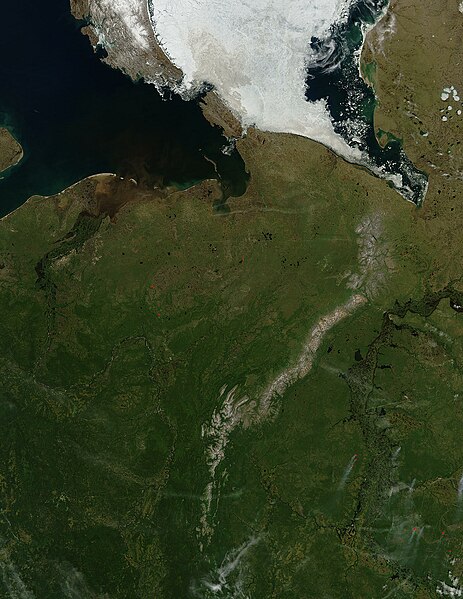
English: Pechora River
sattelite photo On July 3, 2004, sea ice still covered much of the Kara Sea in Northeastern Russia, near the western edge of Siberia, when the Moderate Resolution Imaging Spectroradiometer (MODIS) on NASA’s Aqua satellite captured this image. The southern tip of Novaya Zemlya Island curves out of the upper left corner of the image and is separated from Vaygach Island by Karskiye Vorota Strait. The narrow Yugorskiy Shar Strait, which separates Vaygach Island from mainland Russia, is clogged with sea ice. To the west, image left, the Pechora River is emptying brown, sediment-rich water into the Pechorskoye Sea. The water is probably loaded with mud as the far north thaws for the summer. In the lower right corner of the image, MODIS has detected a handful of fires, marked in red, which are sending light plumes of smoke to the southwest. |
| Origem | Obra do próprio |
| Autor | user:Svart |
Licenciamento
| Este ficheiro está no domínio público nos Estados Unidos porque foi criado exclusivamente pela NASA. As orientações sobre o direito de autor da NASA são que «as obras da NASA não têm os direitos de autor protegidos salvo indicação em contrário». Veja Template:PD-USGov, as orientações sobre o direito de autor da NASA ou as normas de uso de imagens do Laboratório de Propulsão a Jato (Jet Propulsion Lab, JPL). | ||
 |
Avisos:
|
Histórico do ficheiro
Clique uma data e hora para ver o ficheiro tal como ele se encontrava nessa altura.
| Data e hora | Miniatura | Dimensões | Utilizador | Comentário | |
|---|---|---|---|---|---|
| atual | 21h47min de 27 de março de 2006 | | 1 700 × 2 200 (803 kB) | Svart~commonswiki | '''Pechora River''' sattelite photo On July 3, 2004, sea ice still covered much of the Kara Sea in Northeastern Russia, near the western edge of Siberia, when the Moderate Resolution Imaging Spectroradiometer (MODIS) on NASA’s Aqua satellite captured |
Utilização local do ficheiro
As seguintes 2 páginas usam este ficheiro:
Utilização global do ficheiro
As seguintes wikis usam este ficheiro:
- af.wikipedia.org
- ar.wikipedia.org
- arz.wikipedia.org
- ast.wikipedia.org
- az.wikipedia.org
- be.wikipedia.org
- bg.wikipedia.org
- bn.wikipedia.org
- ca.wikipedia.org
- ceb.wikipedia.org
- ce.wikipedia.org
- de.wikivoyage.org
- diq.wikipedia.org
- en.wikipedia.org
- eo.wikipedia.org
- es.wikipedia.org
- eu.wikipedia.org
- fi.wikipedia.org
- fr.wikivoyage.org
- ga.wikipedia.org
- gl.wikipedia.org
- he.wikipedia.org
- hy.wikipedia.org
- id.wikipedia.org
- lmo.wikipedia.org
- lv.wikipedia.org
- mhr.wikipedia.org
- mrj.wikipedia.org
- myv.wikipedia.org
Ver mais utilizações globais deste ficheiro.