
Ficheiro:Pollution over east China.jpg

Imagem numa resolução maior (6 000 × 4 600 píxeis, tamanho: 2,12 MB, tipo MIME: image/jpeg)
|
|
Esta imagem provém do Wikimedia Commons, um acervo de conteúdo livre da Wikimedia Foundation que pode ser utilizado por outros projetos.
|
Descrição do ficheiro
| Descrição |
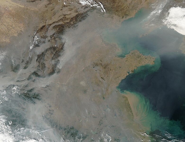
This true-color image over eastern China was acquired by the Moderate Resolution Imaging Spectroradiometer (MODIS), flying aboard NASA’s Aqua satellite, on Oct. 16, 2002 [1]. The scene reveals dozens of fires burning on the surface (red dots) and a thick pall of smoke and haze (greyish pixels) filling the skies overhead. Notice in the high-resolution version of this image how the smog fills the valleys and courses around the contours of the terrain in China’s hilly and mountainous regions. The terrain higher in elevation is less obscured by the smog than the lower lying plains and valleys in the surrounding countryside. This scene spans roughly from Beijing (near top center) to the Yangtze River, the mouth of which can be seen toward the bottom right. Toward the upper right corner, the Bo Hai Bay is rather obscured by the plume of pollution blowing eastward toward Korea and the Pacific Ocean. Toward the bottom right, the Yangtze River is depositing its brownish, sediment-laden waters into the Yellow Sea. |
| Origem | |
| Autor |
Licenciamento
| Este ficheiro está no domínio público nos Estados Unidos porque foi criado exclusivamente pela NASA. As orientações sobre o direito de autor da NASA são que «as obras da NASA não têm os direitos de autor protegidos salvo indicação em contrário». Veja Template:PD-USGov, as orientações sobre o direito de autor da NASA ou as normas de uso de imagens do Laboratório de Propulsão a Jato (Jet Propulsion Lab, JPL). | ||
 |
Avisos:
|
Registo de carregamento original
- 2007-03-16 02:27 Kgrr 6000×4600×8 (2227952 bytes) This true-color image over eastern China was acquired by the Moderate Resolution Imaging Spectroradiometer (MODIS), flying aboard NASA’s Aqua satellite, on Oct. 16, 2002 [http://earthobservatory.nasa.gov/Newsroom/NewImages/images.php3?img_id=10795]. Th
Histórico do ficheiro
Clique uma data e hora para ver o ficheiro tal como ele se encontrava nessa altura.
| Data e hora | Miniatura | Dimensões | Utilizador | Comentário | |
|---|---|---|---|---|---|
| atual | 10h52min de 23 de março de 2007 | | 6 000 × 4 600 (2,12 MB) | Liftarn | {{Information |Description=This true-color image over eastern China was acquired by the Moderate Resolution Imaging Spectroradiometer (MODIS), flying aboard NASA’s Aqua satellite, on Oct. 16, 2002 [http://earthobservatory.nasa.gov/Newsroom/NewImages/ima |
Utilização local do ficheiro
As seguintes 5 páginas usam este ficheiro:
Utilização global do ficheiro
As seguintes wikis usam este ficheiro:
- ar.wikipedia.org
- arz.wikipedia.org
- ast.wikipedia.org
- ca.wikipedia.org
- cs.wikipedia.org
- en.wikipedia.org
- es.wikipedia.org
- eu.wikipedia.org
- fa.wikipedia.org
- fi.wikipedia.org
- fr.wikipedia.org
- fy.wikipedia.org
- id.wikipedia.org
- it.wikipedia.org
- ml.wikipedia.org
- nl.wikipedia.org
- no.wikipedia.org
- oc.wikipedia.org
- pl.wikipedia.org
- si.wikipedia.org
- sq.wikibooks.org
- ta.wikipedia.org
- zh.wikipedia.org