
Ficheiro:Sand Mountain volcanic field.jpg
Sem resolução maior disponível.
Sand_Mountain_volcanic_field.jpg (640 × 422 píxeis, tamanho: 32 kB, tipo MIME: image/jpeg)
|
|
Esta imagem provém do Wikimedia Commons, um acervo de conteúdo livre da Wikimedia Foundation que pode ser utilizado por outros projetos.
|
| Descrição |
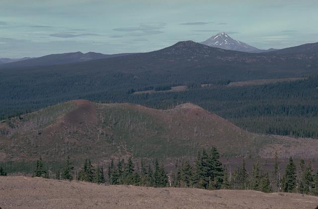
English: The Sand Mountain volcanic field contains a group of 23 cinder cones erupted along a N-S line NW of Mount Washington.
|
|||
| Data | ||||
| Origem | http://www.volcano.si.edu/world/volcano.cfm?vnum=1202-04-&volpage=photos&photo=030029 | |||
| Autor | Lee Siebert (Smithsonian Institution) | |||
| Permissão (Reutilizar este ficheiro) |
|
Histórico do ficheiro
Clique uma data e hora para ver o ficheiro tal como ele se encontrava nessa altura.
| Data e hora | Miniatura | Dimensões | Utilizador | Comentário | |
|---|---|---|---|---|---|
| atual | 16h00min de 27 de maio de 2010 | | 640 × 422 (32 kB) | Michael Metzger | {{Information |Description={{en|1=The Sand Mountain volcanic field contains a group of 23 cinder cones erupted along a N-S line NW of Mount Washington. Two cone alignments diverge at the highest cone, Sand Mountain; this view looks along the NNE alignment |
Utilização local do ficheiro
A seguinte página usa este ficheiro:
Utilização global do ficheiro
As seguintes wikis usam este ficheiro:
- de.wikipedia.org
- en.wikipedia.org
- no.wikipedia.org
- www.wikidata.org