
Ficheiro:Satellite image of Denmark in July 2001.jpg

Dimensões desta antevisão: 800 × 596 píxeis. Outras resoluções: 320 × 239 píxeis | 640 × 477 píxeis | 1 024 × 763 píxeis | 1 280 × 954 píxeis | 1 905 × 1 420 píxeis.
Imagem numa resolução maior (1 905 × 1 420 píxeis, tamanho: 190 kB, tipo MIME: image/jpeg)
|
|
Esta imagem provém do Wikimedia Commons, um acervo de conteúdo livre da Wikimedia Foundation que pode ser utilizado por outros projetos.
|
| Este ficheiro está no domínio público nos Estados Unidos porque foi criado exclusivamente pela NASA. As orientações sobre o direito de autor da NASA são que «as obras da NASA não têm os direitos de autor protegidos salvo indicação em contrário». Veja Template:PD-USGov, as orientações sobre o direito de autor da NASA ou as normas de uso de imagens do Laboratório de Propulsão a Jato (Jet Propulsion Lab, JPL). | ||
 |
Avisos:
|
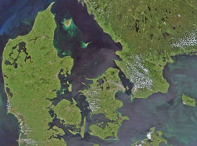
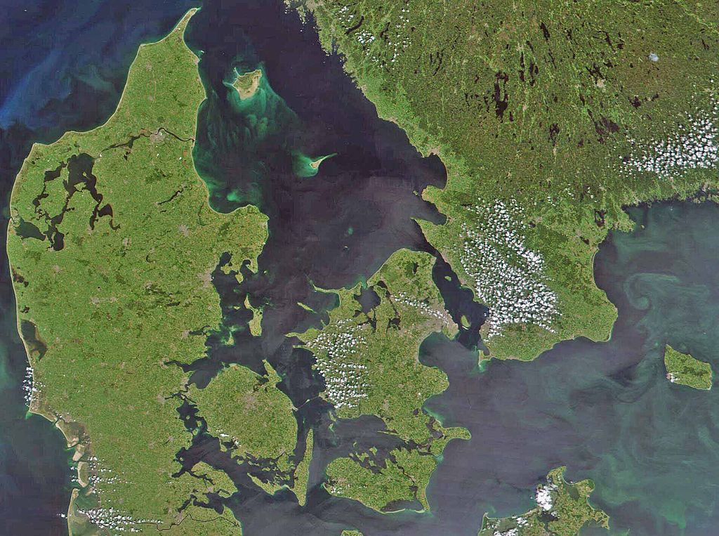
Satellite image of Denmark in July 2001. Cropped image, original taken from NASA's Visible Earth http://visibleearth.nasa.gov/view_rec.php?id=1909
- Interestingly, the Danish-German border is incorrectly placed. The line shown on the map has the correct shape, but is located c. 10 kilometres south of the current border. The line should have been positioned between the islands Rømø and Sylt in the west, and through the fjord to the east. Valentinian (talk) 17:09, 12 November 2006 (UTC)
Histórico do ficheiro
Clique uma data e hora para ver o ficheiro tal como ele se encontrava nessa altura.
| Data e hora | Miniatura | Dimensões | Utilizador | Comentário | |
|---|---|---|---|---|---|
| atual | 08h39min de 24 de fevereiro de 2008 | | 1 905 × 1 420 (190 kB) | XcepticZP | Color correction, ligthened up. Smaller file size due to better jpg compression. |
| 14h22min de 10 de abril de 2005 |  | 1 905 × 1 420 (369 kB) | Hautala | {{PD-USGov-NASA}} Satellite image of Denmark in July 2001. Cropped image, original taken from NASA's Visible Earth http://visibleearth.nasa.gov/view_rec.php?id=1909 |
Utilização local do ficheiro
A seguinte página usa este ficheiro:
Utilização global do ficheiro
As seguintes wikis usam este ficheiro:
- af.wikipedia.org
- arz.wikipedia.org
- az.wikipedia.org
- be.wikipedia.org
- bn.wikipedia.org
- ca.wikipedia.org
- ceb.wikipedia.org
- ce.wikipedia.org
- cs.wikipedia.org
- da.wikipedia.org
- Diskussion:København
- Diskussion:Odense
- Diskussion:Hjørring
- Diskussion:Faaborg
- Diskussion:Barneholm
- Svæveflyveklubber i Danmark
- Diskussion:Frederiksberg
- Diskussion:Ærøskøbing
- Diskussion:Frederikssund
- Diskussion:Kalundborg
- Diskussion:Nykøbing Falster
- Skabelon:Klik
- Diskussion:Nivå
- Bruger:Sir48/Sandkasse
- Diskussion:Frederiksværk
- Diskussion:Djævleø
- Diskussion:Frederikshavn
- Diskussion:Lillerød
- Diskussion:Helsingør
- Diskussion:Hørsholm
- Diskussion:Roskilde
- Diskussion:Visborg (by)
- Diskussion:Rønne
- Diskussion:Svendborg
- Diskussion:Slagelse
- Portal:Danmark
- Portal:Danmark/Introtekst
- Diskussion:Næstved
- Diskussion:Fugleholm
- Diskussion:Nexø
- Diskussion:Nakskov
- Diskussion:Allinge-Sandvig
- Diskussion:Sorø
- Diskussion:Rudkøbing
- Diskussion:Lysbro (Silkeborg)
- Skabelondiskussion:Kortpositioner/doc
- Diskussion:Holbæk
- Diskussion:Halsted
Ver mais utilizações globais deste ficheiro.