
Ficheiro:Satellite image of Hokkaido, Japan in January 2003.jpg

Dimensões desta antevisão: 471 × 599 píxeis. Outras resoluções: 188 × 240 píxeis | 377 × 480 píxeis | 603 × 768 píxeis | 804 × 1 024 píxeis | 2 200 × 2 800 píxeis.
Imagem numa resolução maior (2 200 × 2 800 píxeis, tamanho: 1,74 MB, tipo MIME: image/jpeg)
|
|
Esta imagem provém do Wikimedia Commons, um acervo de conteúdo livre da Wikimedia Foundation que pode ser utilizado por outros projetos.
|
Descrição do ficheiro
Descrição do ficheiro
| Descrição |
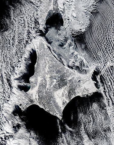
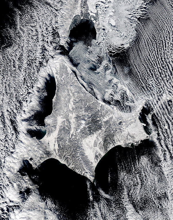
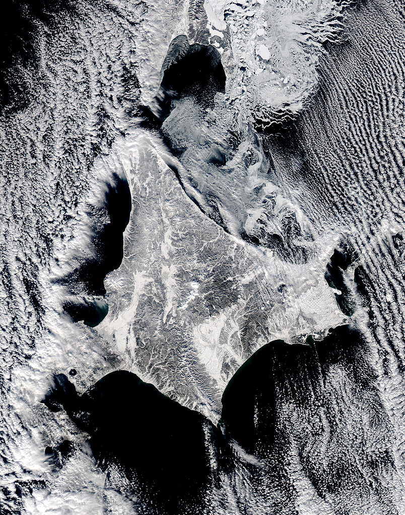
English: Satellite image of Hokkaido, Japan in January 2003. This stunning true-color image shows clouds surrounding northern Japan’s snow-dusted Hokkaido Island in between the black waters of two seas and an ocean. Hokkaido Island is home to the city of Sapporo, which is located on the lower western side near where the island’s tail begins to curve south toward the main island of Japan (middle lower left) and not far from the Ishikari-wan, the north-facing bay that has a streak of clouds moving horizontally across it. Hokkaido’s northern point reaches toward the Russian island of Sakhalin (top center), while the eastern point stretches toward the Kuril Islands, a volcanic chain that eventually connects to the Russian Kamchatka Peninsula. Between Hokkaido’s northern and eastern points lies the southern reaches of the Sea of Okhotsk (upper right), while the northern and southern points lie along the Sea of Japan. From its southern to eastern point, the Pacific Ocean laps at Hokkaido’s shores. This Aqua MODIS image was acquired January 15, 2003. |
| Data | |
| Origem | NASA's Visible Earth http://visibleearth.nasa.gov/view_rec.php?id=4720 |
| Autor | NASA's Visible Earth |
Licenciamento
| Este ficheiro está no domínio público nos Estados Unidos porque foi criado exclusivamente pela NASA. As orientações sobre o direito de autor da NASA são que «as obras da NASA não têm os direitos de autor protegidos salvo indicação em contrário». Veja Template:PD-USGov, as orientações sobre o direito de autor da NASA ou as normas de uso de imagens do Laboratório de Propulsão a Jato (Jet Propulsion Lab, JPL). | ||
 |
Avisos:
|
Histórico do ficheiro
Clique uma data e hora para ver o ficheiro tal como ele se encontrava nessa altura.
| Data e hora | Miniatura | Dimensões | Utilizador | Comentário | |
|---|---|---|---|---|---|
| atual | 22h02min de 7 de maio de 2006 | | 2 200 × 2 800 (1,74 MB) | Akanemoto~commonswiki | Satellite image of Hokkaido, Japan in January 2003. Taken from NASA's Visible Earth http://visibleearth.nasa.gov/view_rec.php?id=4720 : This stunning true-color image shows clouds surrounding northern Japan’s snow-dusted Hokkaido Island in between the |
Utilização local do ficheiro
A seguinte página usa este ficheiro:
Utilização global do ficheiro
As seguintes wikis usam este ficheiro:
- ast.wikipedia.org
- az.wikipedia.org
- ba.wikipedia.org
- en.wikipedia.org
- es.wikipedia.org
- id.wikipedia.org
- it.wikipedia.org
- ja.wikipedia.org
- km.wikipedia.org
- pam.wikipedia.org
- ru.wikinews.org
- tg.wikipedia.org
- vi.wikipedia.org