
Ficheiro:Satellite image of Spain in January 2003.jpg

Dimensões desta antevisão: 714 × 600 píxeis. Outras resoluções: 286 × 240 píxeis | 571 × 480 píxeis | 914 × 768 píxeis | 1 219 × 1 024 píxeis | 2 437 × 2 048 píxeis | 4 175 × 3 508 píxeis.
Imagem numa resolução maior (4 175 × 3 508 píxeis, tamanho: 2,42 MB, tipo MIME: image/jpeg)
|
|
Esta imagem provém do Wikimedia Commons, um acervo de conteúdo livre da Wikimedia Foundation que pode ser utilizado por outros projetos.
|
| Descrição |
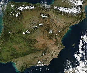
Satellite image of Spain in January 2003. Slightly cropped image, original taken from NASA's Visible Earth http://visibleearth.nasa.gov/view_rec.php?id=4989. NASA's description: The Iberian Peninsula, home to the countries of Spain and Portugal, stretches toward North Africa in this true-color Aqua MODIS image from January 24, 2003. Portugal sits on the Atlantic side of the peninsula, while Spain takes up the rest and shares a border with France to the northeast. At the bottom of the peninsula is a narrow gap between Europe and North Africa. This gap is the Strait of Gibraltar, which also serves as the buffer between the Atlantic Ocean and the Mediterranean Sea. The northern point of Morocco occupies the other side of the Strait, and farther to the east is northern Algeria. |
| Data | |
| Origem | http://visibleearth.nasa.gov/view_rec.php?id=4989 |
| Autor | Jacques Descloitres, MODIS Rapid Response Team, NASA/GSFC |
| Este ficheiro está no domínio público nos Estados Unidos porque foi criado exclusivamente pela NASA. As orientações sobre o direito de autor da NASA são que «as obras da NASA não têm os direitos de autor protegidos salvo indicação em contrário». Veja Template:PD-USGov, as orientações sobre o direito de autor da NASA ou as normas de uso de imagens do Laboratório de Propulsão a Jato (Jet Propulsion Lab, JPL). | ||
 |
Avisos:
|
Histórico do ficheiro
Clique uma data e hora para ver o ficheiro tal como ele se encontrava nessa altura.
| Data e hora | Miniatura | Dimensões | Utilizador | Comentário | |
|---|---|---|---|---|---|
| atual | 12h54min de 20 de dezembro de 2004 | | 4 175 × 3 508 (2,42 MB) | Hautala | {{PD-USGov-NASA}} Satellite image of Spain in January 2003. Slightly cropped image, original taken from NASA's Visible Earth http://visibleearth.nasa.gov/cgi-bin/viewrecord?24848 . Description: The Iberian Peninsula, home to the countries of Spain and Por |
Utilização local do ficheiro
A seguinte página usa este ficheiro:
Utilização global do ficheiro
As seguintes wikis usam este ficheiro:
- af.wikipedia.org
- en.wikipedia.org
- es.wikipedia.org
- eu.wikipedia.org
- he.wikipedia.org
- ht.wikipedia.org
- hu.wikipedia.org
- incubator.wikimedia.org
- it.wikibooks.org
- it.wiktionary.org
- nl.wikipedia.org
- uk.wikipedia.org