
Ficheiro:Spitsbergen labelled.png
Spitsbergen_labelled.png (451 × 446 píxeis, tamanho: 161 kB, tipo MIME: image/png)
|
|
Esta imagem provém do Wikimedia Commons, um acervo de conteúdo livre da Wikimedia Foundation que pode ser utilizado por outros projetos.
|
Descrição do ficheiro
| Descrição |
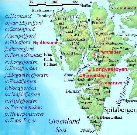
English: Map detailing the marine features of Spitsbergen in the Svalbard archipelago. Settlements and mountains are indicated and labelled. See also Image:Spitsbergen mountains and marine features labelled.png. Locations were labelled mainly based on detailed maps from svalbard-images.com (sample of south Spitsbergen linked), cross-referenced with other map sources where possible. Norwegian Polar Institute figures were used for mountain names and heights, which are given in meters above sea level. |
| Data | 25 de julho de 2006 (data de carregamento original) |
| Origem | A fonte não foi fornecida de forma legível por computadores. Presume-se que seja obra própria (com base nos direitos de autor reivindicados). |
| Autor | O autor não foi fornecido de forma legível por computadores. Presume-se que seja TheGrappler (com base nos direitos de autor reivindicados). |
Licenciamento
DEMIS World Map Server cópia arquivada at the Wayback Machine generated this map from Public Domain sources. DEMIS does not claim any rights over the resultant image ([1] cópia arquivada at the Wayback Machine). Alterations, including the addition of settlements and captions, were performed on 24 July 2006 by User:TheGrappler, the uploader, who releases all associated rights.
| Eu, titular dos direitos de autor desta obra, dedico-a ao domínio público, com aplicação em todo o mundo. Nalguns países isto pode não ser legalmente possível; se assim for: Concedo a todos o direito de usar esta obra para qualquer fim, sem quaisquer condições, a menos que tais condições sejam impostas por lei. |
This image is in the public domain because it came from the site https://www.demis.nl/products/web-map-server/examples/ and was released by the copyright holder. Permission is granted to copy, distribute and/or modify this map since it is based on free of copyright images from: www.demis.nl. See also approval email on de.wp and its clarification.
|
| Esta obra foi colocada em domínio público pelo detentor dos direitos autorais, www.demis.nl. Isto se aplica em todo o mundo. Nalguns países isto pode não ser legalmente possível; se assim for: www.demis.nl concede a todos o direito de usar esta obra para qualquer fim, sem quaisquer condições, a menos que tais condições sejam impostas por lei.
|
Histórico do ficheiro
Clique uma data e hora para ver o ficheiro tal como ele se encontrava nessa altura.
| Data e hora | Miniatura | Dimensões | Utilizador | Comentário | |
|---|---|---|---|---|---|
| atual | 09h23min de 26 de julho de 2006 | | 451 × 446 (161 kB) | TheGrappler | More detail in South |
| 00h58min de 25 de julho de 2006 |  | 451 × 446 (159 kB) | TheGrappler | Move "Albert I Land" label slightly, to avoid obscuring Magdalenefjorden | |
| 00h46min de 25 de julho de 2006 |  | 451 × 446 (160 kB) | TheGrappler | == Summary == {{English}} Map detailing the marine features of Spitsbergen in the Svalbard archipelago. Settlements and mountains are indicated and labelled. See also Image:Spitsbergen mountains and marine features labelled.png. Locations were labell |
Utilização local do ficheiro
As seguintes 3 páginas usam este ficheiro:
Utilização global do ficheiro
As seguintes wikis usam este ficheiro:
- af.wikipedia.org
- ast.wikipedia.org
- az.wikipedia.org
- bg.wikipedia.org
- ca.wikipedia.org
- ceb.wikipedia.org
- cv.wikipedia.org
- da.wikipedia.org
- de.wikipedia.org
- el.wikipedia.org
- en.wikipedia.org
- Spitsbergen
- Danes Island
- Isfjorden (Svalbard)
- Wijdefjorden
- Van Mijenfjorden
- Olav V Land
- Fairhaven (Svalbard)
- Bellsund
- Magdalenefjorden
- Recherche Fjord
- Forlandsundet
- Engelskbukta
- Amsterdam Island (Spitsbergen)
- Van Muydenbukta
- Van Keulenfjorden
- Krossfjorden
- Billefjorden
- Adventfjorden
- Grønfjorden
- Ekmanfjorden
- Moffen
Ver mais utilizações globais deste ficheiro.