
Ficheiro:TY Xangsane 20060926 TRMM.jpg
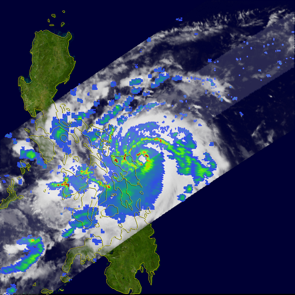
Imagem numa resolução maior (1 024 × 1 024 píxeis, tamanho: 606 kB, tipo MIME: image/jpeg)
|
|
Esta imagem provém do Wikimedia Commons, um acervo de conteúdo livre da Wikimedia Foundation que pode ser utilizado por outros projetos.
|
Descrição do ficheiro
| Descrição |
Typhoon Xangsane (known as Milenyo in the Philippines) brought strong winds and heavy rain to the central Philippines after making landfall on the island of Samar. The storm was reported to have had winds gusting to 150 kilometers per hour (93 miles per hour) as it made landfall. Xangsane began as a tropical depression (area of low air pressure) on September 25, 2006, in the western Philippine Sea just 320 kilometers (200 miles) east of the central islands. As Xangsane headed west-northwest towards the central Philippines, the storm system at first grew only slowly, remaining a tropical storm at the start of the day on September 26. However, as it was nearing Samar, Xangsane began to intensify rapidly into a Category 2 typhoon. This image of Typhoon Xangsane shows the storm system at 1:36 p.m. (21:36 UTC) on September 26, as observed by the Tropical Rainfall Measuring Mission (TRMM) satellite. It shows Xangsane bearing down on northern Samar in the central Philippines. Xangsane had a complete eyewall (ring of clouds around the eye), with moderate to heavy rain (green ring with areas of red) surrounded by spiral rain bands. These features show the well-developed circulation typical of a mature tropical cyclone. At the time of these images, Xangsane was estimated to have had sustained winds of 120 kilometers per hour (75 mph), making it a minimal Category 1 typhoon. However, the storm was in the process of intensifying, and it became a Category 2 storm just hours later as it drew closer to Samar. The TRMM satellite was placed into service in November 1997. From its low-earth orbit, TRMM provides valuable images and information on storm systems around the tropics using a combination of passive microwave and active radar sensors, including the first precipitation radar in space. TRMM is a joint mission between NASA and the Japanese space agency, JAXA. |
|||||
| Data | ||||||
| Origem | http://earthobservatory.nasa.gov/NaturalHazards/natural_hazards_v2.php3?img_id=13902 | |||||
| Autor | Image produced by Hal Pierce (SSAI/NASA GSFC) and caption by Steve Lang (SSAI/NASA GSFC) | |||||
| Permissão (Reutilizar este ficheiro) |
|

Histórico do ficheiro
Clique uma data e hora para ver o ficheiro tal como ele se encontrava nessa altura.
| Data e hora | Miniatura | Dimensões | Utilizador | Comentário | |
|---|---|---|---|---|---|
| atual | 05h37min de 8 de outubro de 2006 | | 1 024 × 1 024 (606 kB) | Coredesat | {{Information |Description=NASA TRMM satellite image showing the well-defined eye of Typhoon Xangsane prior to its first landfall on Samar Island on September 26, 2006. |Source=[http://earthobservatory.nasa.gov/NaturalHazards/natural_hazards_v2.php3?img_i |
Utilização local do ficheiro
A seguinte página usa este ficheiro:
Utilização global do ficheiro
As seguintes wikis usam este ficheiro:
- en.wikipedia.org