
Ficheiro:Tanggu Truce Map.jpg

Dimensões desta antevisão: 794 × 600 píxeis. Outras resoluções: 318 × 240 píxeis | 635 × 480 píxeis | 1 016 × 768 píxeis | 1 280 × 967 píxeis | 1 985 × 1 500 píxeis.
Imagem numa resolução maior (1 985 × 1 500 píxeis, tamanho: 403 kB, tipo MIME: image/jpeg)
|
|
Esta imagem provém do Wikimedia Commons, um acervo de conteúdo livre da Wikimedia Foundation que pode ser utilizado por outros projetos.
|
Descrição do ficheiro
| Descrição |
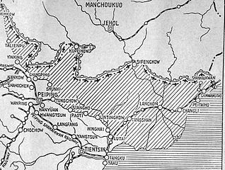
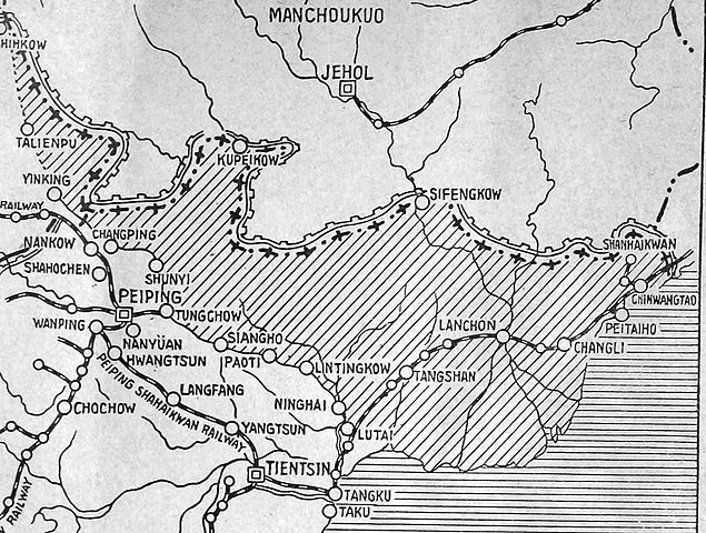
English: The shaded part of this map shows the areas demilitarized by the Tanggu Truce. Note also that the remainder of the Hebei Province, including Beijing and Tianjin, would also be demilitarized of Nationalist forces under the terms of the He-Umezu Agreement, but independent warlords like Song Zheyuan continued to operate there. |
| Data | |
| Origem | a pamphlet called "Sino-Japanese Conflict Elucidated" |
| Autor | Canadian Japanese Association |
Licenciamento
This Canadian work, of which the author or authors are unknown, is in the public domain in Canada because:
(R.S.C., 2020, c. C-42, s. 6.1, R.S.C., 1993, c. C-42, s. 6.1) |
 | |
|
|
Histórico do ficheiro
Clique uma data e hora para ver o ficheiro tal como ele se encontrava nessa altura.
| Data e hora | Miniatura | Dimensões | Utilizador | Comentário | |
|---|---|---|---|---|---|
| atual | 22h47min de 18 de outubro de 2012 | | 1 985 × 1 500 (403 kB) | CurtisNaito | User created page with UploadWizard |
Utilização local do ficheiro
A seguinte página usa este ficheiro:
Utilização global do ficheiro
As seguintes wikis usam este ficheiro:
- ar.wikipedia.org
- en.wikipedia.org
- es.wikipedia.org
- fa.wikipedia.org
- fr.wikipedia.org
- it.wikipedia.org
- ko.wikipedia.org
- lv.wikipedia.org
- nl.wikipedia.org
- ru.wikipedia.org
- uk.wikipedia.org