
Ficheiro:Track map for the Pau street circuit -- 2007.svg

Dimensões desta antevisão em PNG do ficheiro SVG: 800 × 552 píxeis Outras resoluções: 320 × 221 píxeis | 640 × 442 píxeis | 1 024 × 707 píxeis | 1 280 × 884 píxeis | 2 560 × 1 767 píxeis | 1 424 × 983 píxeis.
Imagem numa resolução maior (ficheiro SVG, de 1 424 × 983 píxeis, tamanho: 189 kB)
|
|
Esta imagem provém do Wikimedia Commons, um acervo de conteúdo livre da Wikimedia Foundation que pode ser utilizado por outros projetos.
|
Descrição do ficheiro
| Descrição |
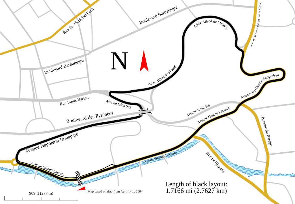
English: Track map for use with Pau Grand Prix. This version shows the track as it was in 2007.
Notes:
|
| Data | |
| Origem | Obra do próprio |
| Autor | Will Pittenger |
| Outras versões |
Older images by other authors for the same track
Same map, but with different data
|

![]]](http://commons.wikimedia.org/wiki/File:Track_map_for_the_Pau_street_circuit_--_2007.svg)
Este(a) desenho vetorial não especificado foi criado com o Inkscape .
| Localização da câmara | | Esta e outras imagens nas suas localizações em: OpenStreetMap |
|---|
Licenciamento
Eu, titular dos direitos de autor desta obra, publico-a com a seguinte licença:
A utilização deste ficheiro é regulada nos termos da licença Creative Commons - Atribuição-CompartilhaIgual 3.0 Não Adaptada.
- Pode:
- partilhar – copiar, distribuir e transmitir a obra
- recombinar – criar obras derivadas
- De acordo com as seguintes condições:
- atribuição – Tem de fazer a devida atribuição da autoria, fornecer uma hiperligação para a licença e indicar se foram feitas alterações. Pode fazê-lo de qualquer forma razoável, mas não de forma a sugerir que o licenciador o apoia ou subscreve o seu uso da obra.
- partilha nos termos da mesma licença – Se remisturar, transformar ou ampliar o conteúdo, tem de distribuir as suas contribuições com a mesma licença ou uma licença compatível com a original.
Histórico do ficheiro
Clique uma data e hora para ver o ficheiro tal como ele se encontrava nessa altura.
| Data e hora | Miniatura | Dimensões | Utilizador | Comentário | |
|---|---|---|---|---|---|
| atual | 03h29min de 12 de fevereiro de 2010 | | 1 424 × 983 (189 kB) | Will Pittenger | The version being reverted is for editing purposes. This version is the viewable verison |
| 03h28min de 12 de fevereiro de 2010 |  | 1 424 × 983 (121 kB) | Will Pittenger | One of these days... | |
| 03h26min de 12 de fevereiro de 2010 |  | 1 424 × 983 (189 kB) | Will Pittenger | Oops. Previous version already had the text on path objects converted into paths. Since a version online is needed that is editable, I have to upload this version. | |
| 03h22min de 12 de fevereiro de 2010 |  | 1 424 × 983 (189 kB) | Will Pittenger | Found out that pit lane was actually in a different spot and moved it to the correct location. Note: Three text objects are now on paths. This version is for editing only. | |
| 21h06min de 6 de fevereiro de 2010 |  | 1 424 × 983 (287 kB) | Will Pittenger | The text objects that were on paths are now plain paths. If you need to edit this file, please follow the instructions in the description. | |
| 21h00min de 6 de fevereiro de 2010 |  | 1 424 × 983 (120 kB) | Will Pittenger | {{Information |Description={{en|1=Track map for use with w:Pau Grand Prix. This version shows the track as it was in w:2007. Notes: *This map has three text objects on paths. MediaWiki/RSVG has a bug causing it to hide all such objects. Henc |
Utilização local do ficheiro
A seguinte página usa este ficheiro:
Utilização global do ficheiro
As seguintes wikis usam este ficheiro:
- ast.wikipedia.org
- cs.wikipedia.org
- de.wikipedia.org
- en.wikipedia.org
- es.wikipedia.org
- fi.wikipedia.org
- hu.wikipedia.org
- it.wikipedia.org
- ja.wikipedia.org
- nl.wikipedia.org
- no.wikipedia.org
- ru.wikipedia.org
- sl.wikipedia.org
- www.wikidata.org