Ficheiro:Types of offshore oil and gas structures.jpg

O conteúdo da página não é suportado noutras línguas.
Origem: Wikipédia, a enciclopédia livre.

Types_of_offshore_oil_and_gas_structures.jpg(600 × 236 píxeis, tamanho: 97 kB, tipo MIME: image/jpeg)

Descrição do ficheiro

Descrição
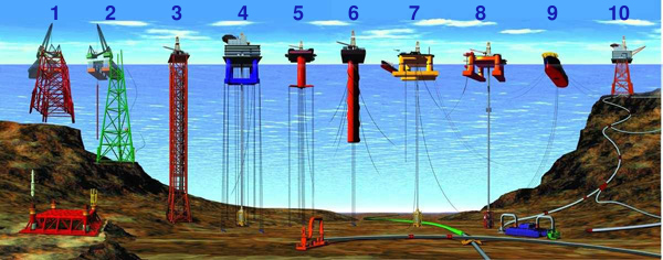
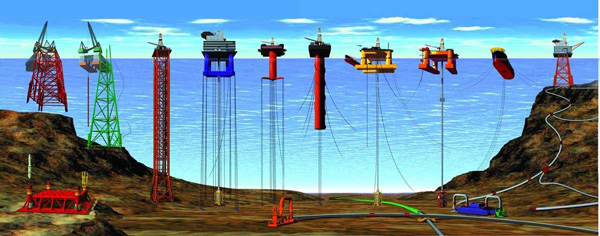
English: Types of Offshore Oil and Gas Structures
  • 1) & 2) Conventional fixed platforms (deepest: Shell’s Bullwinkle in 1991 at 412 m/1,353 ft GOM)
  • 3) Compliant tower (deepest: ChevronTexaco’s Petronius in 1998 at 534 m /1,754 ft GOM)
  • 4) & 5) Vertically moored tension leg and mini-tension leg platform (deepest: ConocoPhillips’ Magnolia in 2004 1,425 m/4,674 ft GOM)
  • 6) Spar (deepest: Dominion’s Devils Tower in 2004, 1,710 m/5,610 ft GOM)
  • 7) & 8) Semi-submersibles (deepest: Shell’s NaKika in 2003, 1920 m/6,300 ft GOM)
  • 9) Floating production, storage, and offloading facility (deepest: 2005, 1,345 m/4,429 ft Brazil)
  • 10) Sub-sea completion and tie-back to host facility (deepest: Shell’s Coulomb tie to NaKika 2004, 2,307 m/ 7,570 ft)
(Numbered from left to right; all records from 2005 data)
Deutsch: Arten von Öl- und Gasbohrinseln
  • 1) & 2) Feste Plattform (tiefste Einsatzstelle: „Bullwinkle“ (Shell) 1991 mit 412 m / 1.353 ft GOM)
  • 3) Turmplattform (tiefste Einsatzstelle: „Petronius“ (ChevronTexaco) 1998 mit 534 m / 1.754 ft GOM)
  • 4) & 5) TLP (für englisch Tension leg platform, wörtl. „Spannbein-Plattform“) (tiefste Einsatzstelle: „Magnolia“ (ConocoPhillips) 2004 mit 1.425 m / 4.674 ft GOM)
  • 6) Spierentonne (englisch Spar) (tiefste Einsatzstelle: Devils Tower (Dominion) in 2004, 1,710 m/5,610 ft GOM)
  • 7) & 8) Halbtaucherborinsel (englisch Semi-submersible rig) (tiefste Einsatzstelle: NaKika (Shell) 2003 mit 1.920 m / 6.300 ft GOM)
  • 9) Schwimmende Produktions- und Lagereinheit (englisch Floating Production Storage and Offloading Unit) (tiefste Einsatzstelle: „Brazil“ 2005 mit 1,345 m/4,429 ft)
  • 10) Completion-Plattform (tiefste Einsatzstelle: Schleppen der „Coulomb“ (Shell) nach Na Kika 2004, 2.307 m / 7.570 ft)
(von links nach rechts; alle Angaben bzgl. tiefsten Einsatzstellen Stand 2005, weitere Informationen in folgenden Artikeln:
  • Bohrinsel (Deutsch) Allgemeiner Artikel zur Bohrinsel (auch die Quelle für die meisten Übersetzungen oben, s. dafür Abschnitt „Bauarten“)
  • Hubinsel (Deutsch) Artikel zu Hubinseln, diese werden auch für Bohrplattformen eingesetzt (s. Abschnitt „Verwendung/Bohrplattformen“) und gehört zu den festen Plattformen.
Was mit dem Ausdruck ‚GOM‘ gemeint war, konnte während der Übersetzung nicht zweifelsfrei angenommen werden. Es wird angenommen, dass er für ‚Gulf of Mexico (deutsch ‚‘) steht. Sofern die Bedeutung geklärt werden konnte, bitte diesen Hinweis entfernen )
Data Revised at 15 de dezembro de 2008
Origem
Autor
  • Office of Ocean Exploration and Research
National Oceanic and Atmospheric Administration (NOAA), US Department of Commerce
  • Graphic originally developed and provided to NOAA by Oil States Industries, Inc., supplier of many of the technologies and connecting systems for these offshore platforms
Outras versões

Licenciamento

Public domain
Esta imagem está em domínio público pois ela contém material que vieram originalmente da National Oceanic and Atmospheric Administration dos EUA, tirada ou feita durante o trajeto de um funcionário em obrigações oficiais.

العربية  čeština  Deutsch  Zazaki  English  español  eesti  suomi  français  hrvatski  magyar  italiano  日本語  한국어  македонски  മലയാളം  Plattdüütsch  Nederlands  polski  português  română  русский  sicilianu  slovenščina  Türkçe  Tiếng Việt  简体中文  繁體中文  +/−

Legendas

Adicione uma explicação de uma linha do que este ficheiro representa

Elementos retratados neste ficheiro

retrata

image/jpeg

Histórico do ficheiro

Clique uma data e hora para ver o ficheiro tal como ele se encontrava nessa altura.

Data e horaMiniaturaDimensõesUtilizadorComentário
atual19h44min de 25 de outubro de 2013Miniatura da versão das 19h44min de 25 de outubro de 2013600 × 236 (97 kB)JaybearNumbers added;
17h56min de 23 de maio de 2010Miniatura da versão das 17h56min de 23 de maio de 2010600 × 236 (72 kB)Emerson7{{Information |Description = Types of offshore oil and gas structures incude: 1, 2) conventional fixed platforms (deepest: Shell’s Bullwinkle in 1991 at 412 m/1,353 ft GOM); 3) compliant tower (deepest: ChevronTexaco’s Petronius in 1998 at 534 m /

A seguinte página usa este ficheiro:

Utilização global do ficheiro

As seguintes wikis usam este ficheiro: