
Ficheiro:United States 1860-1870.gif
Sem resolução maior disponível.
United_States_1860-1870.gif (787 × 483 píxeis, tamanho: 49 kB, tipo MIME: image/gif, cíclico, 28 quadros, 35 s)
|
|
Esta imagem provém do Wikimedia Commons, um acervo de conteúdo livre da Wikimedia Foundation que pode ser utilizado por outros projetos.
|
Descrição do ficheiro
| Descrição |
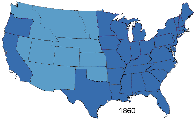
English: Animated map, about the American Civil War and the restoration of the southern states and the Union (made in Photoshop).
States of the Union (with full delegations in the U.S. Congress)
Union Territories (including the southern states before and during the war)
States of the Confederacy
Territories of the Confederacy |
| Origem | Based on Creative Commons Licenced 1861 map and GNU-1864 Licenced map. Information from the Wikipedia articles Confederate States of America, List of US states by date of statehood, and has also just exterior sites When states Became states. Civil war borders Used from public domain Perry-Castañeda Library Map Collection 1861-1865 map. Border Between Arizona Territory (CSA) and New Mexico Territory Is That Depicted in public domain map Image: Map of CSA 4.png |
| Autor | User:Roke~commonswiki |
Licenciamento
As the maps this was based on were licenced as GFDL and creative commons (not including the public domain maps), this is licenced under both licences.

|
É concedida permissão para copiar, distribuir e/ou modificar este documento nos termos da Licença de Documentação Livre GNU, versão 1.2 ou qualquer versão posterior publicada pela Free Software Foundation; sem Secções Invariantes, sem textos de Capa e sem textos de Contra-Capa. É incluída uma cópia da licença na secção intitulada GNU Free Documentation License. |
| A utilização deste ficheiro é regulada nos termos da licença Creative Commons - Atribuição-CompartilhaIgual 3.0 Não Adaptada. | ||
| ||
| Esta marca de licenciamento foi adicionada a este ficheiro durante a atualização da licença GFDL. |
A utilização deste ficheiro é regulada nos termos da licença Creative Commons - Atribuição-CompartilhaIgual 2.5 Genérica.
- Pode:
- partilhar – copiar, distribuir e transmitir a obra
- recombinar – criar obras derivadas
- De acordo com as seguintes condições:
- atribuição – Tem de fazer a devida atribuição da autoria, fornecer uma hiperligação para a licença e indicar se foram feitas alterações. Pode fazê-lo de qualquer forma razoável, mas não de forma a sugerir que o licenciador o apoia ou subscreve o seu uso da obra.
- partilha nos termos da mesma licença – Se remisturar, transformar ou ampliar o conteúdo, tem de distribuir as suas contribuições com a mesma licença ou uma licença compatível com a original.
Histórico do ficheiro
Clique uma data e hora para ver o ficheiro tal como ele se encontrava nessa altura.
| Data e hora | Miniatura | Dimensões | Utilizador | Comentário | |
|---|---|---|---|---|---|
| atual | 14h02min de 2 de janeiro de 2015 | | 787 × 483 (49 kB) | Sapph | Fixed incorrect succession order of North Carolina and Tennessee by swapping frames 10 and 11. |
| 05h00min de 2 de agosto de 2006 |  | 787 × 483 (49 kB) | Roke~commonswiki | Animated map showing Confederacy, American Civil War and re-admission of southern states to the Union, made in Photoshop. {{legend|#376dae|States of the Union}} {{legend|#5b9dc8|Territories of the Union (including occupied territory during and after the |
Utilização local do ficheiro
A seguinte página usa este ficheiro:
Utilização global do ficheiro
As seguintes wikis usam este ficheiro:
- af.wikipedia.org
- ar.wikipedia.org
- bn.wikipedia.org
- ca.wikipedia.org
- cs.wikipedia.org
- en.wikipedia.org
- Historical regions of the United States
- History of the Southern United States
- Wikipedia:Featured picture candidates/March-2007
- Wikipedia:Featured picture candidates/CSA states evolution.gif
- Portal:American Civil War/Intro/images
- Portal:American Civil War/Intro/images/rotation/41
- Talk:United States/Archive 36
- es.wikipedia.org
- eu.wikipedia.org
- fa.wikipedia.org
- fr.wikipedia.org
- it.wikipedia.org
- ja.wikipedia.org
- lt.wikipedia.org
- ms.wikipedia.org
- www.wikidata.org