
Ficheiro:Viedma volcanic complex.jpg
Sem resolução maior disponível.
Viedma_volcanic_complex.jpg (640 × 422 píxeis, tamanho: 64 kB, tipo MIME: image/jpeg)
|
|
Esta imagem provém do Wikimedia Commons, um acervo de conteúdo livre da Wikimedia Foundation que pode ser utilizado por outros projetos.
|
Descrição do ficheiro
| Descrição |
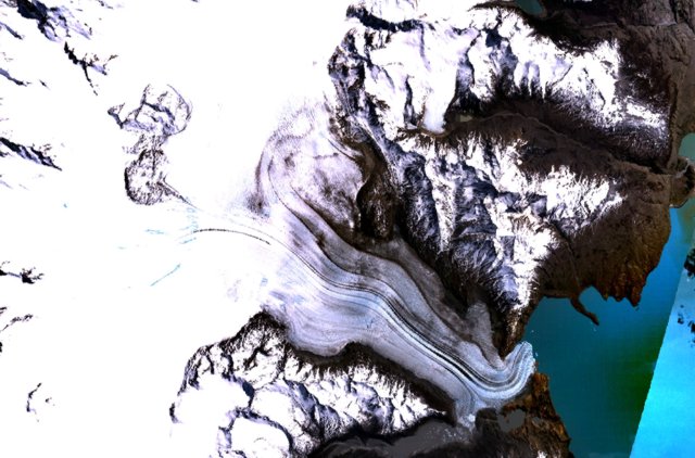
English: The figure-8-shaped area rising above the Patagonian Icefield at the upper left part of this NASA Landsat mosaic is part of the Viedma volcanic complex. An outflow glacier descends into Lake Viedma at the lower right. This mostly subglacial volcano produced an eruption in 1988 that confirmed the presence of a postulated subglacial vent in the Patagonian Icefield NW of Viedma Lake. The 1988 eruption deposited ash and pumice on the icecap and produced a mudflow that reached Viedma Lake. |
| Data | Data desconhecida |
| Origem | http://www.volcano.si.edu/world/volcano.cfm?vnum=1508-061&volpage=photos&photo=115011 |
| Autor | NASA Landsat7 image (worldwind.arc.nasa.gov) |
Licenciamento
| This image is in the public domain because it is a screenshot from NASA’s globe software World Wind using a public domain layer, such as Blue Marble, MODIS, Landsat, SRTM, USGS or GLOBE.
|
 |
Histórico do ficheiro
Clique uma data e hora para ver o ficheiro tal como ele se encontrava nessa altura.
| Data e hora | Miniatura | Dimensões | Utilizador | Comentário | |
|---|---|---|---|---|---|
| atual | 15h37min de 15 de outubro de 2010 | | 640 × 422 (64 kB) | Michael Metzger | {{Information |Description={{en|1= The figure-8-shaped area rising above the Patagonian Icefield at the upper left part of this NASA Landsat mosaic is part of the Viedma volcanic complex. An outflow glacier descends into Lake Viedma at the lower right. Th |
Utilização local do ficheiro
A seguinte página usa este ficheiro:
Utilização global do ficheiro
As seguintes wikis usam este ficheiro:
- arz.wikipedia.org
- cs.wikipedia.org
- de.wikipedia.org
- en.wikipedia.org
- es.wikipedia.org
- fr.wikipedia.org
- sk.wikipedia.org
- uk.wikipedia.org
- www.wikidata.org