
Ficheiro:Vredefort.jpg

Dimensões desta antevisão: 800 × 600 píxeis. Outras resoluções: 320 × 240 píxeis | 640 × 480 píxeis | 1 024 × 768 píxeis.
Imagem numa resolução maior (1 024 × 768 píxeis, tamanho: 266 kB, tipo MIME: image/jpeg)
|
|
Esta imagem provém do Wikimedia Commons, um acervo de conteúdo livre da Wikimedia Foundation que pode ser utilizado por outros projetos.
|
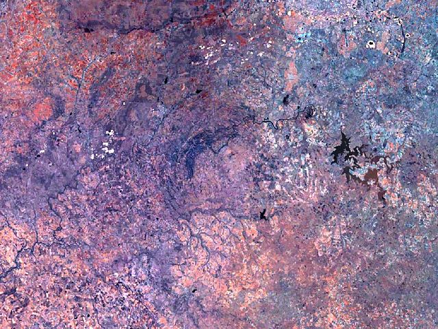
| Descrição | Vredefort crater has a diameter of 300 km, and its circular structure nearly fills the complete image. The Vredefort dome, a conspicuous geologic feature about 50 km in diameter, stands out at the center. |
| Origem | Created with NASA WorldWind by User:Vesta using Landsat 7 (Visible Color) satellite image. |
| Autor | User:Vesta |
27°0′0″S 27°30′0″E / 27°S 27.5°E
| This image is in the public domain because it is a screenshot from NASA’s globe software World Wind using a public domain layer, such as Blue Marble, MODIS, Landsat, SRTM, USGS or GLOBE.
|
 |
Histórico do ficheiro
Clique uma data e hora para ver o ficheiro tal como ele se encontrava nessa altura.
| Data e hora | Miniatura | Dimensões | Utilizador | Comentário | |
|---|---|---|---|---|---|
| atual | 09h12min de 7 de janeiro de 2006 | | 1 024 × 768 (266 kB) | Vesta~commonswiki | * '''Description:''' Vredefort crater has a diameter of 300 km, and its circular structure nearly fills the complete image. The Vredefort ring, a conspicuous feature, 50 km in diameter, stands out at the center. *'''Source:''' Created with NASA WorldWind |
Utilização local do ficheiro
A seguinte página usa este ficheiro:
Utilização global do ficheiro
As seguintes wikis usam este ficheiro:
- avk.wikipedia.org
- be.wikipedia.org
- de.wikipedia.org
- de.wikivoyage.org
- es.wikipedia.org
- hr.wikipedia.org
- hy.wikipedia.org
- it.wikipedia.org
- lt.wikipedia.org
- ml.wikipedia.org
- ru.wikipedia.org
- sh.wikipedia.org
- sv.wikipedia.org