
Ficheiro:Western Polynesia and Polynesian Outliers - fr.svg

Imagem numa resolução maior (ficheiro SVG, de 1 238 × 939 píxeis, tamanho: 4,02 MB)
|
|
Esta imagem provém do Wikimedia Commons, um acervo de conteúdo livre da Wikimedia Foundation que pode ser utilizado por outros projetos.
|
Descrição do ficheiro
| Descrição |
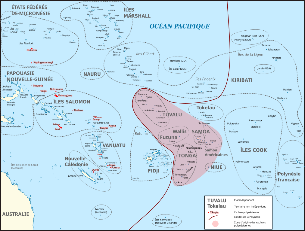
Français : Carte du Pacifique montrant la Polynésie occidentale et les différentes exclaves polynésiennes (en rouge). La zone en rouge clair correspond à la zone originelle de peuplement de Polynésie, d'où sont parties les populations qui habitent les exclaves polynésiennes. Les traits entourant les différents territoires ne sont pas les frontières maritimes actuelles, simplement un repère.
Carte d’origine : File:BLANK in Oceania (small islands magnified) (-mini map -rivers).svg Sources pour les noms des îles : Fidji : File:FijiOMCmap.png Nouvelle-Calédonie et Vanuatu :
Îles Salomon :
Tonga: FIle:Tonga.jpg Micronésie : File:Micronesia,_administrative_divisions_with_island_names_-_colored_-_fr.svg Îles Marshall: Kiribati :
Polynésie française : File:French_Polynesia_relief_map.svg Liste des exclaves polynésiennes : https://fr.wikipedia.org/wiki/Exclaves_polyn%C3%A9siennes
English: Map of Oceania showing Polynesian outliers. The red zone is the original Polynesian homeland, from where Polynesian seafarers went to the various Polynesian outliers. The lines around countries and territories are not the actual maritime borders.
Sources for this map : Original map : File:BLANK in Oceania (small islands magnified) (-mini map -rivers).svg Island names : Fidji : File:FijiOMCmap.png New Caledonia and Vanuatu
Solomon Islands :
Tonga: FIle:Tonga.jpg Micronesia: File:Micronesia,_administrative_divisions_with_island_names_-_colored_-_fr.svg Marshall islands: Kiribati :
French Polynesia : File:French_Polynesia_relief_map.svg List of Polynesian Outliers : https://fr.wikipedia.org/wiki/Exclaves_polyn%C3%A9siennes |
| Data | |
| Origem | Obra do próprio |
| Autor | Skimel |
_(-mini_map_-rivers).svg)
.png)
Licenciamento
- Pode:
- partilhar – copiar, distribuir e transmitir a obra
- recombinar – criar obras derivadas
- De acordo com as seguintes condições:
- atribuição – Tem de fazer a devida atribuição da autoria, fornecer uma hiperligação para a licença e indicar se foram feitas alterações. Pode fazê-lo de qualquer forma razoável, mas não de forma a sugerir que o licenciador o apoia ou subscreve o seu uso da obra.
- partilha nos termos da mesma licença – Se remisturar, transformar ou ampliar o conteúdo, tem de distribuir as suas contribuições com a mesma licença ou uma licença compatível com a original.
Histórico do ficheiro
Clique uma data e hora para ver o ficheiro tal como ele se encontrava nessa altura.
| Data e hora | Miniatura | Dimensões | Utilizador | Comentário | |
|---|---|---|---|---|---|
| atual | 13h44min de 12 de novembro de 2016 | | 1 238 × 939 (4,02 MB) | Skimel | Changed the fonts to DejaVu Sans condensed, resized the map, changed the shape of some country borders to fit the text better. |
| 11h50min de 12 de novembro de 2016 |  | 2 476 × 1 885 (3,99 MB) | Skimel | Fixed the black box in the upper left corner, resized the map so that one can zoom in more (but apparently caused other black rectangles...) | |
| 13h22min de 11 de novembro de 2016 |  | 617 × 466 (3,98 MB) | Skimel | User created page with UploadWizard |
Utilização local do ficheiro
A seguinte página usa este ficheiro:
Utilização global do ficheiro
As seguintes wikis usam este ficheiro:
- ca.wikipedia.org
- en.wikipedia.org
- es.wikipedia.org
- fr.wikipedia.org
- it.wikipedia.org
- ja.wikipedia.org
- ko.wikipedia.org