
Ficheiro:Burstall Priory - geograph.org.uk - 322572.jpg
Sem resolução maior disponível.
Burstall_Priory_-_geograph.org.uk_-_322572.jpg (640 × 481 píxeis, tamanho: 113 kB, tipo MIME: image/jpeg)
|
|
Esta imagem provém do Wikimedia Commons, um acervo de conteúdo livre da Wikimedia Foundation que pode ser utilizado por outros projetos.
|
Descrição do ficheiro
| Descrição |
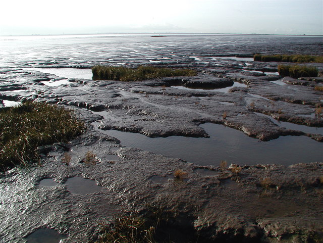
English: Burstall Priory, Skeffling, East Riding of Yorkshire, England. The River Humber, a hundred metres or so from the bank where the unpredictable saltmarsh gives way to a vast expanse of mud. Somewhere beneath all this is the site of Burstall Priory, founded by the Albermarle family of Normandy on land granted to them by William the Conqueror. The monks here were apparently subject to many hardships including the frequent seizure of their land during hostilities between England and France. The Priory was in ruins by 1720 and the last traces of it disappeared during floods in the 1900s. Bits of the property were salvaged over the centuries, including a stone doorway which is now in Easington Church and a tomb which was moved into the church at Welwick. Burstall Lane which once connected the priory with Skeffling village is now nothing more than a public footpath along a field drain but it does give a clue to the priory's former location. |
| Data | |
| Origem | From geograph.org.uk |
| Autor | Paul Glazzard |
| Permissão (Reutilizar este ficheiro) |
Creative Commons Attribution Share-alike license 2.0 |
| Atribuição (requerido pela licença) | Paul Glazzard / Burstall Priory / |
| Localização da câmara | | Esta e outras imagens nas suas localizações em: OpenStreetMap |
|---|
_heading:247.00&language=pt)
| Localização do objecto | | Esta e outras imagens nas suas localizações em: OpenStreetMap |
|---|
_heading:247.00&language=pt)
Licenciamento

|
Esta imagem foi tirada da coleção do projeto Geografia. Ver a página desta fotografia no website Geograph para detalhes de contato do fotógrafo. O direito autoral desta imagem pertence a Paul Glazzard e está licenciado para reuso sob a licença Creative Commons Atribuição-Compartilhamento pela mesma Licença.
|
A utilização deste ficheiro é regulada nos termos da licença Creative Commons - Atribuição-CompartilhaIgual 2.0 Genérica.
Atribuição: Paul Glazzard
- Pode:
- partilhar – copiar, distribuir e transmitir a obra
- recombinar – criar obras derivadas
- De acordo com as seguintes condições:
- atribuição – Tem de fazer a devida atribuição da autoria, fornecer uma hiperligação para a licença e indicar se foram feitas alterações. Pode fazê-lo de qualquer forma razoável, mas não de forma a sugerir que o licenciador o apoia ou subscreve o seu uso da obra.
- partilha nos termos da mesma licença – Se remisturar, transformar ou ampliar o conteúdo, tem de distribuir as suas contribuições com a mesma licença ou uma licença compatível com a original.
Histórico do ficheiro
Clique uma data e hora para ver o ficheiro tal como ele se encontrava nessa altura.
| Data e hora | Miniatura | Dimensões | Utilizador | Comentário | |
|---|---|---|---|---|---|
| atual | 18h19min de 30 de dezembro de 2010 | | 640 × 481 (113 kB) | GeographBot | == {{int:filedesc}} == {{Information |description={{en|1=Burstall Priory The River Humber, a hundred metres or so from the bank where the unpredictable saltmarsh gives way to a vast expanse of mud. Somewhere beneath all this is the site of Burstall Priory |
Utilização local do ficheiro
A seguinte página usa este ficheiro:
Utilização global do ficheiro
As seguintes wikis usam este ficheiro:
- en.wikipedia.org