
Ficheiro:Cape Verde hurricane track.jpg

Dimensões desta antevisão: 800 × 296 píxeis. Outras resoluções: 320 × 118 píxeis | 640 × 237 píxeis | 1 024 × 379 píxeis | 2 550 × 944 píxeis.
Imagem numa resolução maior (2 550 × 944 píxeis, tamanho: 317 kB, tipo MIME: image/jpeg)
|
|
Esta imagem provém do Wikimedia Commons, um acervo de conteúdo livre da Wikimedia Foundation que pode ser utilizado por outros projetos.
|
| Descrição |
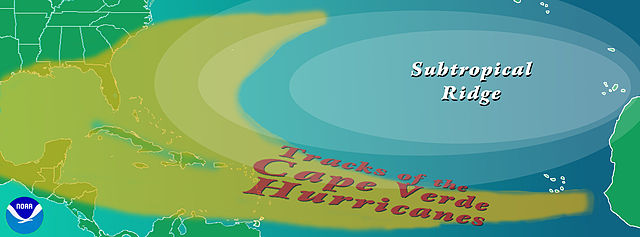
English: Graphic showing the typical track of a en:Cape Verde-type hurricane. The tracks begin south of en:Cape Verde in the eastern en:Atlantic Ocean.
Copyright statusThe NOAA emblem is the property of the U.S. Government and a trademark of the en:United States Department of Commerce. SourceNOAA graphic from http://www.aoml.noaa.gov/hrd/tcfaq/CVtrak.jpg en:nl:Afbeelding:KaapverdischeOrkanen.jpg |
| Data | 16 de julho de 2004 (data de carregamento original) |
| Origem | Transferido de en.wikipedia para a wiki Commons por OhanaUnited. |
| Autor | Este ficheiro foi inicialmente carregado por Cyrius em Wikipédia em inglês |
| Outras versões |
|
Licenciamento


Esta imagem está em domínio público pois ela contém material que vieram originalmente da National Oceanic and Atmospheric Administration dos EUA, tirada ou feita durante o trajeto de um funcionário em obrigações oficiais.
|
Registo de carregamento original
A página de descrição original está aqui. Todos os nomes de utilizador a seguir referem-se a en.wikipedia.
- 2004-07-16 00:36 Cyrius 2550×944×??? (324839 bytes) PD graphic from NOAA
Histórico do ficheiro
Clique uma data e hora para ver o ficheiro tal como ele se encontrava nessa altura.
| Data e hora | Miniatura | Dimensões | Utilizador | Comentário | |
|---|---|---|---|---|---|
| atual | 17h40min de 21 de agosto de 2008 | 2 550 × 944 (317 kB) | OhanaUnited | {{Information |Description={{en|Graphic showing the typical track of a en:Cape Verde-type hurricane. The tracks begin south of en:Cape Verde in the eastern en:Atlantic Ocean. ==Copyright status== The NOAA emblem is the property of the [[:e |
Utilização local do ficheiro
A seguinte página usa este ficheiro:
Utilização global do ficheiro
As seguintes wikis usam este ficheiro:
- ca.wikipedia.org
- en.wikipedia.org
- es.wikipedia.org
- eu.wikipedia.org
- fi.wikipedia.org
- fr.wikipedia.org
- it.wikipedia.org
- ko.wikipedia.org
- nl.wikipedia.org
- uk.wikipedia.org
- www.wikidata.org