
Ficheiro:Earth 720Ma.gif

Dimensões desta antevisão: 800 × 450 píxeis. Outras resoluções: 320 × 180 píxeis | 640 × 360 píxeis | 1 024 × 576 píxeis | 1 280 × 720 píxeis | 1 920 × 1 080 píxeis.
Imagem numa resolução maior (1 920 × 1 080 píxeis, tamanho: 211 kB, tipo MIME: image/gif, cíclico, 0,5 s)
|
|
Esta imagem provém do Wikimedia Commons, um acervo de conteúdo livre da Wikimedia Foundation que pode ser utilizado por outros projetos.
|
Descrição do ficheiro
| Descrição |
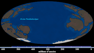
English: Hand-drawn images of the Earth around that timeframe. (Based on the first frame of the source GIF, which says this is 740 Ma. But i re-estimate this into around ~720 Ma based on the position of the continents with new Algol's video (at 9:20), which also has new and updated sources) With Algol's video and given that yellow stripe (that estimates the time) doesn't give when it is happening, i gave this illustration with a new estimate. Since this is an estimate, the exact time cannot be measured. Note: this is not a map of Rodinia, this is a map when Rodinia is breaking up at 720 Ma. |
| Data | |
| Origem | File:Continental Drift (740 million-to-Today).gif |
| Autor | SebM123 |
.gif)
Licenciamento
| A utilização deste ficheiro é regulada nos termos Creative Commons - CC0 1.0 Dedicação Universal ao Domínio Público. | |
| A pessoa que associou uma obra a este documento dedicou-a ao domínio público, renunciando a todos os seus direitos sobre a obra em todo o mundo ao abrigo da legislação de direitos de autor, incluindo a todos os direitos legais conexos, na medida permitida por lei. Pode copiar, modificar, distribuir e executar a obra, até com fins comerciais, sem pedir autorização.
|
Histórico do ficheiro
Clique uma data e hora para ver o ficheiro tal como ele se encontrava nessa altura.
| Data e hora | Miniatura | Dimensões | Utilizador | Comentário | |
|---|---|---|---|---|---|
| atual | 04h35min de 22 de maio de 2020 | | 1 920 × 1 080 (211 kB) | MarioJump83 | Uploaded a work by SebM123 from File:Continental Drift (740 million-to-Today).gif with UploadWizard |
.gif)
Utilização local do ficheiro
As seguintes 2 páginas usam este ficheiro:
Utilização global do ficheiro
As seguintes wikis usam este ficheiro:
- cy.wikipedia.org
- fi.wikibooks.org
- tr.wikipedia.org
- www.wikidata.org