
Ficheiro:Fly River Map 1876 NLA.jpg

Dimensões desta antevisão: 800 × 533 píxeis. Outras resoluções: 320 × 213 píxeis | 640 × 427 píxeis | 1 024 × 683 píxeis | 1 280 × 853 píxeis | 1 950 × 1 300 píxeis.
Imagem numa resolução maior (1 950 × 1 300 píxeis, tamanho: 475 kB, tipo MIME: image/jpeg)
|
|
Esta imagem provém do Wikimedia Commons, um acervo de conteúdo livre da Wikimedia Foundation que pode ser utilizado por outros projetos.
|
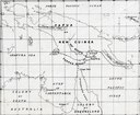
| Descrição | Fly river, Papua New Guinea: as surveyed by L. M. D'Albertis on board the steam launch "Neva" 1876 |
| Data | |
| Origem | http://www.nla.gov.au/apps/cdview?pi=nla.map-f469-sd |
| Autor | L. M. D'Albertis |
| Outras versões |
This image or other work is of Australian origin and is now in the public domain because its term of copyright has expired. According to the Australian Copyright Council (ACC), ACC Information Sheet G023v19 (Duration of copyright) (January 2019).1
When using this template, please provide information of where the image was first published and who created it. |
 | |||||||||||||||||||
Histórico do ficheiro
Clique uma data e hora para ver o ficheiro tal como ele se encontrava nessa altura.
| Data e hora | Miniatura | Dimensões | Utilizador | Comentário | |
|---|---|---|---|---|---|
| atual | 04h27min de 24 de julho de 2007 | | 1 950 × 1 300 (475 kB) | Nomadtales | {{Information |Description=Fly river, Papua New Guinea: as surveyed by L. M. D'Albertis on board the steam launch "Neva" 1876 |Source=http://www.nla.gov.au/apps/cdview?pi=nla.map-f469-sd |Date=1876 |Author=L. M. D'Albertis |Permission= |other_versions= }} |
Utilização local do ficheiro
A seguinte página usa este ficheiro:
Utilização global do ficheiro
As seguintes wikis usam este ficheiro:
- als.wikipedia.org
- ast.wikipedia.org
- az.wikipedia.org
- ca.wikipedia.org
- cv.wikipedia.org
- de.wikipedia.org
- en.wikipedia.org
- eo.wikipedia.org
- es.wikipedia.org
- hy.wikipedia.org
- id.wikipedia.org
- ml.wikipedia.org
- nl.wikipedia.org
- no.wikipedia.org
- ru.wikipedia.org