
Ficheiro:Hallandsåstunneln OSM zoom 11 slim.png
Sem resolução maior disponível.
Hallandsåstunneln_OSM_zoom_11_slim.png (300 × 360 píxeis, tamanho: 112 kB, tipo MIME: image/png)
|
|
Esta imagem provém do Wikimedia Commons, um acervo de conteúdo livre da Wikimedia Foundation que pode ser utilizado por outros projetos.
|
| Descrição |
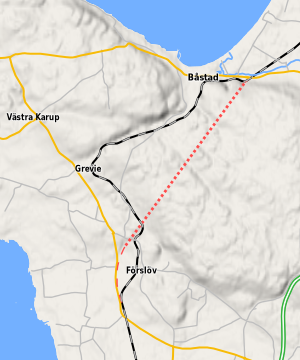
Map of the area around Hallandsåstunneln in Sweden. The dotted red line is the tunnel and the dashed red line is the connecting railway. Este mapa foi criado com dados do projeto OpenStreetMap, coligidos pela comunidade. O mapa pode estar incompleto e pode conter erros. Não dependa exclusivamente dele para navegação. |
| Data | |
| Origem | openstreetmap.org |
| Criador |
Map data: OpenStreetMap contributors, rendering: Erik Lundin. contribuidores do OpenStreetMap |
| Permissão (Reutilizar este ficheiro) |
Os dados e mapas do OpenStreetMap são disponibilizados com a licença Atribuição-CompartilhaIgual 2.0 (CC-BY-SA 2.0) da Creative Commons. A utilização deste ficheiro é regulada nos termos da licença Creative Commons - Atribuição-CompartilhaIgual 2.0 Genérica.
|
| Georeferenciamento | Se inapropriado, por favor defina warp_status = skip para ocultar. |
| Outras versões |
This is a cropped version of File:Hallandsåstunneln_OSM_zoom_11.png. Slippy map at openstreetmap.org |
Histórico do ficheiro
Clique uma data e hora para ver o ficheiro tal como ele se encontrava nessa altura.
| Data e hora | Miniatura | Dimensões | Utilizador | Comentário | |
|---|---|---|---|---|---|
| atual | 02h09min de 6 de janeiro de 2012 | | 300 × 360 (112 kB) | Luen | {{OpenStreetMap |description=Map of the area around Hallandsåstunneln in Sweden. The dotted red line is the tunnel and the dashed red line is the connecting railway. |authors=Map data: OpenStreetMap contributors, rendering: Erik Lundin. |da |
Utilização local do ficheiro
A seguinte página usa este ficheiro:
Utilização global do ficheiro
As seguintes wikis usam este ficheiro:
- da.wikipedia.org
- no.wikipedia.org
- sv.wikipedia.org