
Ficheiro:Hurricane Laura 2020-08-26 LCH radar loop of landfall.gif
Hurricane_Laura_2020-08-26_LCH_radar_loop_of_landfall.gif (600 × 550 píxeis, tamanho: 230 kB, tipo MIME: image/gif, cíclico, 8 quadros, 4,1 s)
|
|
Esta imagem provém do Wikimedia Commons, um acervo de conteúdo livre da Wikimedia Foundation que pode ser utilizado por outros projetos.
|
Descrição do ficheiro
| Descrição |
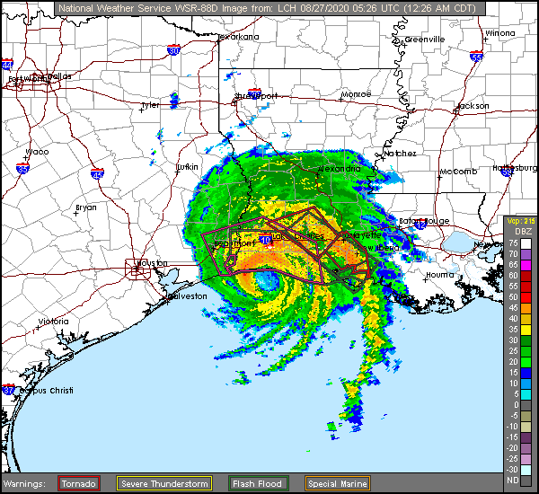
English: A radar loop of Hurricane Laura's landfall followed by the failure of the radar. An extreme wind warning, tornado warnings, and flash flood warnings were all in effect at that time. |
| Data | |
| Origem | https://radar.weather.gov/ridge/radar_lite.php?product=N0Z&rid=LCH&loop=yes |
| Autor | NWS Lake Charles |
Licenciamento
| This file is in the public domain in the United States because it was solely created by the National Weather Service (NWS), including its name from 1870–1970, the United States Weather Bureau (USWB).
This includes the sub-branches of the National Weather Service:
As a file created by an employee of the NWS (formerly USWB) in the course of their official duties, whether hosted
this work is in the public domain in the United States because it is a work prepared by an officer or employee of the United States Government as part of that person’s official duties under the terms of Title 17, Chapter 1, Section 105 of the US Code. |
||
 |
Warnings: (Click Here To View)
|
Histórico do ficheiro
Clique uma data e hora para ver o ficheiro tal como ele se encontrava nessa altura.
| Data e hora | Miniatura | Dimensões | Utilizador | Comentário | |
|---|---|---|---|---|---|
| atual | 14h23min de 27 de agosto de 2020 | | 600 × 550 (230 kB) | ChessEric | Uploaded a work by NWS Lake Charles from https://radar.weather.gov/ridge/radar_lite.php?product=N0Z&rid=LCH&loop=yes with UploadWizard |
Utilização local do ficheiro
A seguinte página usa este ficheiro:
Utilização global do ficheiro
As seguintes wikis usam este ficheiro:
- en.wikipedia.org
- fr.wikipedia.org
- hi.wikipedia.org