
Ficheiro:King 1950-10-18 weather map.jpg

Dimensões desta antevisão: 800 × 569 píxeis. Outras resoluções: 320 × 228 píxeis | 640 × 455 píxeis | 1 024 × 729 píxeis | 1 130 × 804 píxeis.
Imagem numa resolução maior (1 130 × 804 píxeis, tamanho: 789 kB, tipo MIME: image/jpeg)
|
|
Esta imagem provém do Wikimedia Commons, um acervo de conteúdo livre da Wikimedia Foundation que pode ser utilizado por outros projetos.
|
Descrição do ficheiro
| Descrição | ||||
| Data | ||||
| Origem | NOAA Central Library Data Imaging Project | |||
| Autor | NOAA Central Library, Silver Spring, Maryland | |||
| Permissão (Reutilizar este ficheiro) |
|
Histórico do ficheiro
Clique uma data e hora para ver o ficheiro tal como ele se encontrava nessa altura.
| Data e hora | Miniatura | Dimensões | Utilizador | Comentário | |
|---|---|---|---|---|---|
| atual | 14h30min de 21 de junho de 2010 | | 1 130 × 804 (789 kB) | Vyznev Xnebara | convert from BMP to JPEG format (with quality 100) |
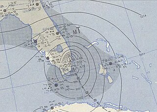
| 00h22min de 21 de setembro de 2009 |  | 1 130 × 804 (2,6 MB) | Iune | {{Information |Description={{en|1=Hurricane King of 1950 near landfall near Miami, Florida.}} |Source=http://docs.lib.noaa.gov/rescue/dwm/data_rescue_daily_weather_maps.html |Author=NOAA |Date=1950 |Permission= |other_versions= }} [[Category:1950 Atlant |
Utilização local do ficheiro
A seguinte página usa este ficheiro:
Utilização global do ficheiro
As seguintes wikis usam este ficheiro:
- de.wikipedia.org
- en.wikipedia.org
- es.wikipedia.org
- min.wikipedia.org
- www.wikidata.org
- zh.wikipedia.org