
Ficheiro:Kingdom of Hungary counties-2.svg

Dimensões desta antevisão em PNG do ficheiro SVG: 779 × 513 píxeis Outras resoluções: 320 × 211 píxeis | 640 × 421 píxeis | 1 024 × 674 píxeis | 1 280 × 843 píxeis | 2 560 × 1 686 píxeis.
Imagem numa resolução maior (ficheiro SVG, de 779 × 513 píxeis, tamanho: 265 kB)
|
|
Esta imagem provém do Wikimedia Commons, um acervo de conteúdo livre da Wikimedia Foundation que pode ser utilizado por outros projetos.
|
| Descrição |
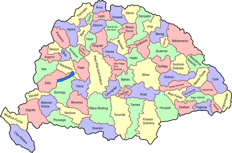
Map of counties of Kingdom of Hungary (Hungary proper and Croatia & Slavonia), 1886-1918. I have organised this into layers: Three layers of paths for the counties, for the county borders, and for external border. and one layer for the text labels. I have added basic styles and classified all elements. I have given all elements reasonable IDs the counties (the county name) and the borders (the names of the counties on each side) and the text labels (the names of the counties, with underscores indicating where they are split across labels). The counties are classed into four styles to make a four colour map, of course the colours can be changed just by changing the style (there as a fifth style for Lake Balaton, which does not show up very well on tis uploaded one). The main thing now is to fix the text styles. |
||
| Data | (UTC) | ||
| Origem | |||
| Autor |
|
||
| Outras versões |
|

| Esta é uma imagem retocada, o que significa que a versão original foi alterada digitalmente. Modificações: As described - added more useful metadata and structure. O original pode ser visto aqui: Kingdom of Hungary counties.svg:
|
Eu, titular dos direitos de autor desta obra, publico-a com a seguinte licença:
| Eu, titular dos direitos de autor desta obra, dedico-a ao domínio público, com aplicação em todo o mundo. Nalguns países isto pode não ser legalmente possível; se assim for: Concedo a todos o direito de usar esta obra para qualquer fim, sem quaisquer condições, a menos que tais condições sejam impostas por lei. |
Registo de carregamento original
This image is a derivative work of the following images:
- File:Kingdom_of_Hungary_counties.svg licensed with PD-self
- 2007-08-20T20:25:30Z Xavax 779x513 (240591 Bytes) == Summary == {{Information| |Description= Map of counties of Hungary with Croatia & Slavonia, 1886-1918 |Source=own drawing |Date=April 30, 2006 |Author=[[User:IMeowbot]] |Permission= |other_versions= }} == Licensing == {{P
- 2006-04-30T22:10:47Z IMeowbot 779x513 (228524 Bytes) line weight
- 2006-04-30T21:34:49Z IMeowbot 779x513 (225942 Bytes)
- 2006-04-30T18:34:30Z IMeowbot 779x513 (199213 Bytes) {{Information| |Description= Map of late 1870s Hungary counties |Source=own drawing |Date=April 30, 2006 |Author=[[User:IMeowbot]] |Permission= |other_versions= }}
Carregada com derivativeFX
Histórico do ficheiro
Clique uma data e hora para ver o ficheiro tal como ele se encontrava nessa altura.
| Data e hora | Miniatura | Dimensões | Utilizador | Comentário | |
|---|---|---|---|---|---|
| atual | 17h57min de 5 de dezembro de 2009 | | 779 × 513 (265 kB) | SimonTrew | I missed some fixes of Veszprém |
| 17h55min de 5 de dezembro de 2009 |  | 779 × 513 (265 kB) | SimonTrew | Fix spelling of Vesprém, as I have just done on original. | |
| 14h29min de 3 de dezembro de 2009 |  | 779 × 513 (265 kB) | SimonTrew | Fix spelling of Pozsony, as I have just done on original work | |
| 13h37min de 3 de dezembro de 2009 |  | 779 × 513 (265 kB) | SimonTrew | Made four colour map. The text still only uses one style at the moment, this needs to be made to match the four styles used for the four colours for the counties, but this is easier to do once it is uploaded and I can print the png. Sorry if this is "not | |
| 11h29min de 3 de dezembro de 2009 |  | 779 × 513 (287 kB) | SimonTrew | Fixed the few errors in borders, removed unnecessary style fields from text (Inkscape adds them but they are covered by other fields), text still needs doing better | |
| 01h16min de 3 de dezembro de 2009 |  | 779 × 513 (286 kB) | SimonTrew | {{Information |Description=Map of counties of Kingdom of Hungary (Hungary proper and Croatia & Slavonia), 1886-1918. I have organised this into layers: Three layers of paths for the counties, for the county borders, and for external border. and one layer |
Utilização local do ficheiro
A seguinte página usa este ficheiro:
Utilização global do ficheiro
As seguintes wikis usam este ficheiro:
- ar.wikipedia.org
- bs.wikipedia.org
- ceb.wikipedia.org
- ckb.wikipedia.org
- da.wikipedia.org
- de.wikipedia.org
- en.wikipedia.org
- User talk:Random user 8384993
- Wikipedia talk:WikiProject Hungary/Archive 2
- Module:Location map/data/Kingdom of Hungary/doc
- Wikipedia:Redirects for discussion/Log/2015 April 19
- User:Drkazmer/Jewish centres in the Kingdom of Hungary
- Wikipedia:Graphics Lab/Map workshop/Archive/2017/Sep 2017
- Module:Location map/data/Kingdom of Hungary
- fa.wikipedia.org
- fr.wikipedia.org
- hu.wikipedia.org
- kn.wikipedia.org
- rue.wikipedia.org
- si.wikipedia.org
- sr.wikipedia.org
- tg.wikipedia.org
- tr.wikipedia.org
- uz.wikipedia.org
- war.wikipedia.org