
Ficheiro:Lexington Concord Siege of Boston.jpg
Imagem numa resolução maior (3 211 × 2 476 píxeis, tamanho: 1,55 MB, tipo MIME: image/jpeg)
|
|
Esta imagem provém do Wikimedia Commons, um acervo de conteúdo livre da Wikimedia Foundation que pode ser utilizado por outros projetos.
|
Descrição do ficheiro
| Descrição |
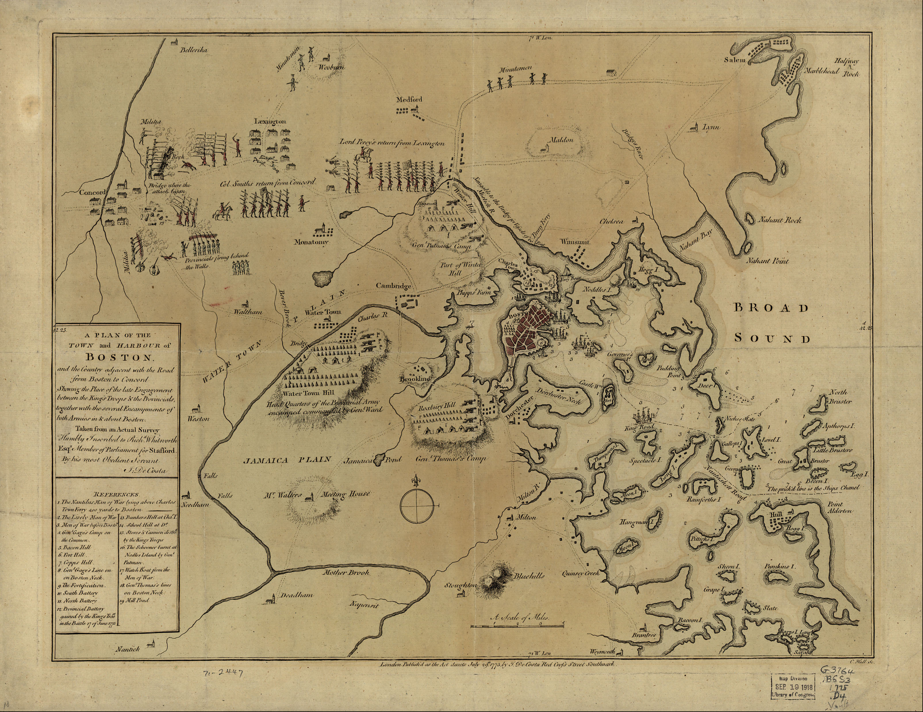
English: A mostly accurate hand-colored map depicting the 1775 Battles of Lexington and Concord and the Siege of Boston |
| Data | |
| Origem |
From the Library of Congress American Memory. |
| Autor | J. DeCosta |
| Outras versões |
 |
Large text box
TOWN and HARBOUR of
Boston.
and the Country adjacent with the Road
from Boston to Concord
Shewing the Place of the late Engagement
between the King's Troops & the Provincials,
together with the several Encampments of
both Armies in & about Boston.
Taken from an Actual Survey
Humbly Inscribed to Rich d. Whitworth
Esqr. Member of Parliament for Stafford
Legend
References.
- The Nautilus Man of War lying above Charles
- Town Ferry 400 yards to Boston
- The Lively Man of War
- Men of War before Boston.
- Gen l. Gage's Camp on
- the Common.
- Bacon Hill [i.e. Beacon Hill]
- Fort Hill.
- Copps Hill.
- Gen l. Gage's Line on
- on Boston Neck.
- The Fortification.
- South Battery
- North Battery
- Provincial Battery
- gained by the King's Troo ps
- in the Battle 17 of June 1775
- Bunkers Hill at Cha s. T.
- School Hill at D o.
- Stores & Cannon destro d
- by the King's Troops
- The Schooner burnt at
- Nodles Island by Gen l.
- Putman
- Watch Boat from the Men of War.
- Gen l. Thomas's lines
- on Boston Neck
- Mill Pond
Text along the bottom
- London Publish'd as the Act directs July 29th. 1775 by J. De Costa Red Croſs Street Southwark.

|
Este mapa está disponível na Divisão de Geografia e Cartografia da Biblioteca do Congresso dos Estados Unidos com o número de identificação digital g3764b.ar090000.
Esta marcação não indica o estado dos direitos de autor da obra aqui mostrada. Continua a ser necessária uma marcação normal de direitos de autor. Veja Commons:Licenciamento para mais informações.
|
|
Esta obra está no domínio público no seu país de origem e noutros países e áreas onde o período de proteção dos direitos de autor é igual ou inferior à vida do autor mais 100 anos. | |
| Este ficheiro foi considerado livre de restrições conhecidas devidas a direitos de autor, incluindo todos os direitos conexos. | |
Histórico do ficheiro
Clique uma data e hora para ver o ficheiro tal como ele se encontrava nessa altura.
| Data e hora | Miniatura | Dimensões | Utilizador | Comentário | |
|---|---|---|---|---|---|
| atual | 07h30min de 10 de maio de 2005 | | 3 211 × 2 476 (1,55 MB) | Flying Jazz | "A plan of the town and harbour of Boston and the country adjacent with the road from Boston to Concord, shewing the place of the late engagement between the King's troops & the provincials, together with the several encampments of both armies in & about |
Utilização local do ficheiro
Não há nenhuma página que use este ficheiro.
Utilização global do ficheiro
As seguintes wikis usam este ficheiro:
- azb.wikipedia.org
- az.wikipedia.org
- ca.wikipedia.org
- cs.wikipedia.org
- da.wikipedia.org
- de.wikipedia.org
- en.wikipedia.org
- en.wikivoyage.org
- es.wikipedia.org
- fi.wikipedia.org
- fo.wikipedia.org
- fr.wikipedia.org
- fr.wikiversity.org
- it.wikipedia.org
- it.wikivoyage.org
- ja.wikipedia.org
- no.wikipedia.org
- pl.wikipedia.org
- ro.wikipedia.org
- sr.wikipedia.org
- th.wikipedia.org
- www.wikidata.org
- zh.wikipedia.org