
Ficheiro:Map of Minnesota highlighting Crow Wing County.svg

Dimensões desta antevisão em PNG do ficheiro SVG: 527 × 600 píxeis Outras resoluções: 211 × 240 píxeis | 422 × 480 píxeis | 675 × 768 píxeis | 900 × 1 024 píxeis | 1 800 × 2 048 píxeis | 1 045 × 1 189 píxeis.
Imagem numa resolução maior (ficheiro SVG, de 1 045 × 1 189 píxeis, tamanho: 67 kB)
|
|
Esta imagem provém do Wikimedia Commons, um acervo de conteúdo livre da Wikimedia Foundation que pode ser utilizado por outros projetos.
|
Descrição do ficheiro
| Descrição |
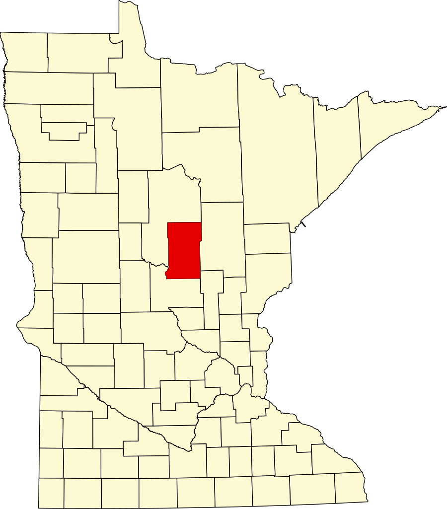
English: This is a locator map showing Crow Wing County in Minnesota. For more information, see Commons:United States county locator maps. |
| Data | |
| Origem |
Obra do próprio: English: The maps use data from nationalatlas.gov, specifically countyp020.tar.gz on the Raw Data Download page. The maps also use state outline data from statesp020.tar.gz. The Florida maps use hydrogm020.tar.gz to display Lake Okeechobee. |
| Autor | David Benbennick |
Licenciamento
| Eu, titular dos direitos de autor desta obra, dedico-a ao domínio público, com aplicação em todo o mundo. Nalguns países isto pode não ser legalmente possível; se assim for: Concedo a todos o direito de usar esta obra para qualquer fim, sem quaisquer condições, a menos que tais condições sejam impostas por lei. |
Histórico do ficheiro
Clique uma data e hora para ver o ficheiro tal como ele se encontrava nessa altura.
| Data e hora | Miniatura | Dimensões | Utilizador | Comentário | |
|---|---|---|---|---|---|
| atual | 02h14min de 25 de junho de 2024 | | 1 045 × 1 189 (67 kB) | Nux | fix rendering (remove clipping) |
| 13h13min de 12 de fevereiro de 2006 |  | 5 746 × 6 539 (104 kB) | David Benbennick | {{subst:User:Dbenbenn/clm|county=Crow Wing County|state=Minnesota|type=county}} | |
| 13h02min de 12 de fevereiro de 2006 |  | 5 746 × 6 539 (104 kB) | David Benbennick | {{subst:User:Dbenbenn/clm|county=Crow Wing County|state=Minnesota|type=county}} |
Utilização local do ficheiro
As seguintes 2 páginas usam este ficheiro:
Utilização global do ficheiro
As seguintes wikis usam este ficheiro:
- ar.wikipedia.org
- bg.wikipedia.org
- bpy.wikipedia.org
- cdo.wikipedia.org
- ceb.wikipedia.org
- cy.wikipedia.org
- da.wikipedia.org
- de.wikipedia.org
- Liste der Countys in Minnesota
- Crow Wing County
- Brainerd (Minnesota)
- Pequot Lakes
- Liste der Einträge im National Register of Historic Places im Crow Wing County
- Baxter (Minnesota)
- Breezy Point (Minnesota)
- Vorlage:Navigationsleiste Orte im Crow Wing County
- Crosby (Minnesota)
- Crosslake
- Nisswa
- Merrifield (Minnesota)
- en.wikipedia.org
Ver mais utilizações globais deste ficheiro.