
Ficheiro:Map of Washington highlighting Douglas County.svg

Dimensões desta antevisão em PNG do ficheiro SVG: 800 × 521 píxeis Outras resoluções: 320 × 208 píxeis | 640 × 417 píxeis | 1 024 × 667 píxeis | 1 280 × 833 píxeis | 2 560 × 1 666 píxeis | 1 696 × 1 104 píxeis.
Imagem numa resolução maior (ficheiro SVG, de 1 696 × 1 104 píxeis, tamanho: 109 kB)
|
|
Esta imagem provém do Wikimedia Commons, um acervo de conteúdo livre da Wikimedia Foundation que pode ser utilizado por outros projetos.
|
Descrição do ficheiro
| Descrição |
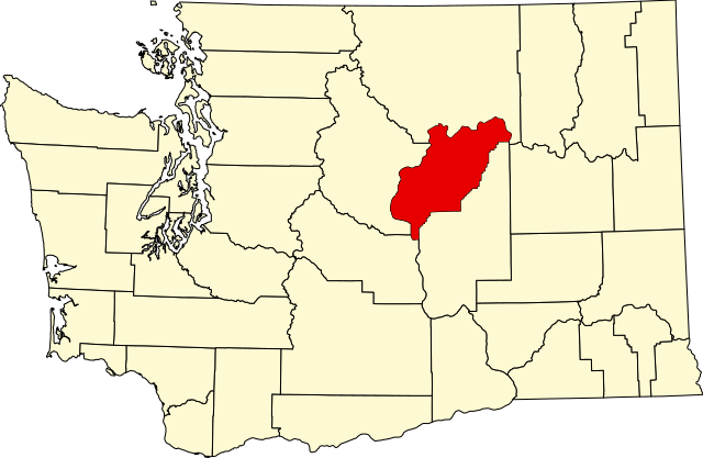
English: This is a locator map showing Douglas County in Washington. For more information, see Commons:United States county locator maps. |
| Data | |
| Origem |
Obra do próprio: English: The maps use data from nationalatlas.gov, specifically countyp020.tar.gz on the Raw Data Download page. The maps also use state outline data from statesp020.tar.gz. The Florida maps use hydrogm020.tar.gz to display Lake Okeechobee. |
| Autor | David Benbennick |
Licenciamento
| Eu, titular dos direitos de autor desta obra, dedico-a ao domínio público, com aplicação em todo o mundo. Nalguns países isto pode não ser legalmente possível; se assim for: Concedo a todos o direito de usar esta obra para qualquer fim, sem quaisquer condições, a menos que tais condições sejam impostas por lei. |
Histórico do ficheiro
Clique uma data e hora para ver o ficheiro tal como ele se encontrava nessa altura.
| Data e hora | Miniatura | Dimensões | Utilizador | Comentário | |
|---|---|---|---|---|---|
| atual | 23h41min de 24 de junho de 2024 | | 1 696 × 1 104 (109 kB) | Nux | fix rendering (remove clipping) |
| 18h03min de 12 de fevereiro de 2006 |  | 5 936 × 3 863 (215 kB) | David Benbennick | {{subst:User:Dbenbenn/clm|county=Douglas County|state=Washington|type=county}} |
Utilização local do ficheiro
A seguinte página usa este ficheiro:
Utilização global do ficheiro
As seguintes wikis usam este ficheiro:
- ar.wikipedia.org
- bg.wikipedia.org
- bpy.wikipedia.org
- cdo.wikipedia.org
- ceb.wikipedia.org
- ce.wikipedia.org
- cs.wikipedia.org
- cy.wikipedia.org
- de.wikipedia.org
- el.wikipedia.org
- en.wikipedia.org
- List of counties in Washington
- Douglas County, Washington
- Bridgeport, Washington
- East Wenatchee, Washington
- East Wenatchee Bench, Washington
- Mansfield, Washington
- Rock Island, Washington
- Waterville, Washington
- Coulee Dam, Washington
- Orondo, Washington
- Template:Douglas County, Washington
- Withrow, Washington
- User:Nyttend/County templates/WA
- Baird, Washington
- Palisades, Washington
- Category:Populated places in Douglas County, Washington
- National Register of Historic Places listings in Douglas County, Washington
- Bonita, Washington
- Jameson, Washington
- Lamoine, Washington
- Saint Andrews, Washington
- Sanderson, Washington
- Douglas, Washington
- User:AridCeption/sandbox
- File talk:Map of Washington highlighting Douglas County.svg
- eo.wikipedia.org
Ver mais utilizações globais deste ficheiro.