
Ficheiro:Map of the War of the Pacific.en.svg

Dimensões desta antevisão em PNG do ficheiro SVG: 515 × 600 píxeis Outras resoluções: 206 × 240 píxeis | 412 × 480 píxeis | 660 × 768 píxeis | 879 × 1 024 píxeis | 1 759 × 2 048 píxeis | 761 × 886 píxeis.
Imagem numa resolução maior (ficheiro SVG, de 761 × 886 píxeis, tamanho: 180 kB)
|
|
Esta imagem provém do Wikimedia Commons, um acervo de conteúdo livre da Wikimedia Foundation que pode ser utilizado por outros projetos.
|
Descrição do ficheiro
| Descrição |
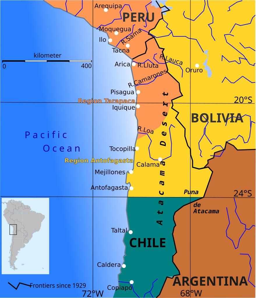
English: Boundary before war (colored areas) and after the War of the Pacific (1879-1883) (black and red lines)
Peruvian territories before the war
Bolivian territories before the war
Chilean territories before the war
Peru-Bolivia Boundary in Atacama Desert according to File:Departamento moquegua 1865.JPG Argentina-Bolivia Boundary in Puna de Atacama and Tarija was contested according to File:MPazSoldan.1888-2xChile.djvu |
||||||
| Data | |||||||
| Origem | Obra do próprio | ||||||
| Autor | Createaccount | ||||||
| Permissão (Reutilizar este ficheiro) |
Eu, titular dos direitos de autor desta obra, publico-a com as seguintes licenças: A utilização deste ficheiro é regulada nos termos da licença Creative Commons - Atribuição-CompartilhaIgual 3.0 Não Adaptada.
Pode escolher a licença que quiser. |
||||||
| Outras versões | File:Wotp.de.svg |

Histórico do ficheiro
Clique uma data e hora para ver o ficheiro tal como ele se encontrava nessa altura.
| Data e hora | Miniatura | Dimensões | Utilizador | Comentário | |
|---|---|---|---|---|---|
| atual | 13h33min de 9 de abril de 2015 | | 761 × 886 (180 kB) | Keysanger | gradient instead of white line at the coast |
| 13h56min de 29 de janeiro de 2015 |  | 761 × 886 (181 kB) | Keysanger | margin cropped. | |
| 13h43min de 29 de janeiro de 2015 |  | 760 × 887 (182 kB) | Keysanger | Back to version with frontiers as for 1929 because they are known and accepted. It is almost impossible to draw all frontiers, at every time for every point of view | |
| 13h27min de 7 de novembro de 2014 |  | 760 × 887 (172 kB) | Keysanger | Argentina+Bolivia colors for disputed zone | |
| 14h14min de 4 de novembro de 2014 |  | 760 × 887 (172 kB) | Keysanger | Puna de Atacama was a disputed zone and also Tarija. | |
| 17h29min de 12 de fevereiro de 2013 |  | 760 × 887 (170 kB) | Citypeek | removal border and removal legenda (to be added on the page itself) | |
| 19h47min de 5 de outubro de 2009 |  | 804 × 1 026 (230 kB) | Keysanger | Now Puna de Atacam reaches ca. 26°S | |
| 12h10min de 4 de outubro de 2009 |  | 804 × 1 026 (232 kB) | Keysanger | Text "Boundary after war" changed to "Chilean boundary after war" | |
| 18h01min de 23 de setembro de 2009 |  | 804 × 1 026 (232 kB) | Keysanger | Title wasn't necessary, Margin was too big | |
| 23h46min de 1 de julho de 2009 |  | 744 × 1 052 (225 kB) | Keysanger | coordinates a white difuse coast line in background |
Utilização local do ficheiro
As seguintes 2 páginas usam este ficheiro:
Utilização global do ficheiro
As seguintes wikis usam este ficheiro:
- ar.wikipedia.org
- ast.wikipedia.org
- az.wikipedia.org
- ba.wikipedia.org
- bg.wikipedia.org
- br.wikipedia.org
- ca.wikipedia.org
- cs.wikipedia.org
- da.wikipedia.org
- en.wikipedia.org
- es.wikipedia.org
- fi.wikipedia.org
- fr.wiktionary.org
- hr.wikipedia.org
- hy.wikipedia.org
- io.wikipedia.org
- ja.wikipedia.org
- mk.wikipedia.org
- no.wikipedia.org
- sr.wikipedia.org
- sv.wikipedia.org
- zh.wikipedia.org