
Ficheiro:Mitchell Map-06full2.jpg

Imagem numa resolução maior (11 686 × 8 255 píxeis, tamanho: 96,59 MB, tipo MIME: image/jpeg)
|
|
Esta imagem provém do Wikimedia Commons, um acervo de conteúdo livre da Wikimedia Foundation que pode ser utilizado por outros projetos.
|
Descrição do ficheiro
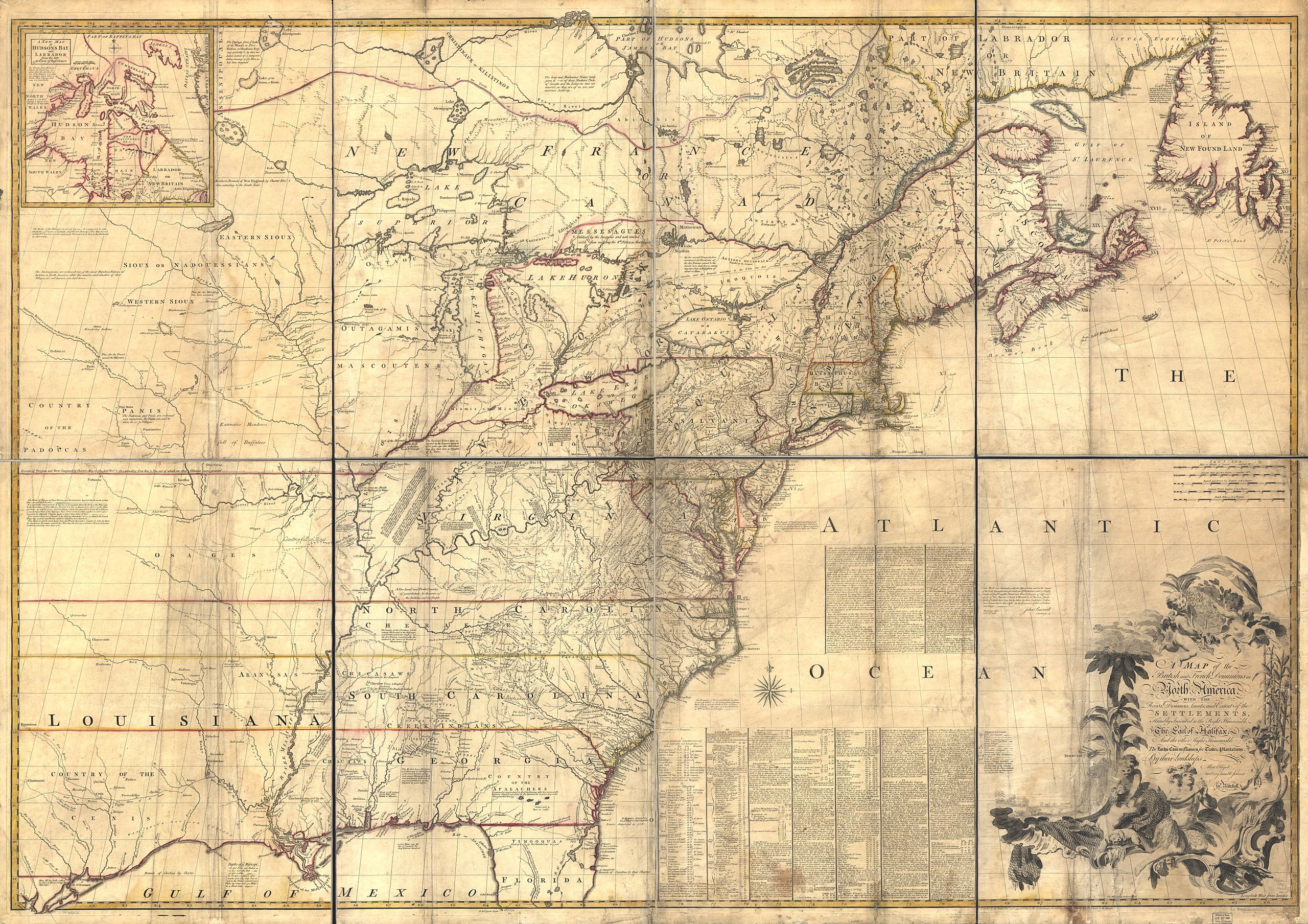
| Descrição | Mitchell Map - A map of the British and French dominions in North America,...; 1757 |
| Data | entre 1755 e 1757 |
| Origem | Library of Congress |
| Autor | John Mitchell; digital version, Library of Congress, Geography and Map Division. |
| Permissão (Reutilizar este ficheiro) |
"The Library of Congress is providing access to these materials for educational and research purposes and is not aware of any U.S. copyright protection" (source: http://memory.loc.gov/cgi-bin/ammemrr.pl?title=Map%20Collections&coll=gmd&div=&agg=g3300&default=ammem&dir=ammem) |
| Outras versões | Mitchell Map-06full2 compressed.jpg (compressed to 19 MB) |
|
Licenciamento
|
Esta obra está no domínio público no seu país de origem e noutros países e áreas onde o período de proteção dos direitos de autor é igual ou inferior à vida do autor mais 100 anos. | |
| Este ficheiro foi considerado livre de restrições conhecidas devidas a direitos de autor, incluindo todos os direitos conexos. | |
Transcription
The first part of the text between "Atlantic" and "Ocean" reads:
After the first drawing of this map in 1750, it was again corrected and improved, before it was published, and I have since taken Care to procure & examine all the information I could get, in order to render it as correct & usefull as possible; which has given occasion to this Second Edition of it, in which I have likewise inserted all the Observations I believe we have for the Geography of N. America, since I find them grossly misrepresented by others.
The Foundation of this Map is the several Manuscript Maps, Charts & Surveys that have been lately made of our Colonies, which represent most Places from the Ocean to the Missisipi. But in order to know the true Situation of those Places, we must have their Latitudes & Longitudes, which are of more Consequence in a general Map, than their bare Shape or Figure, which we only find represented in our Draughts & Surveys. But after having consulted all the Observations I believe that we have, I found the true Situation, or Latitude & Longitude, of many Places was undetermined or uncertain; & that we had no Accounts of them, but what might be found in the Journals of our Ships of War kept in the Admiralty Office; which I had Recourse to for that reason, and have extracted from them whatever relates to our purposem which are the chief Source of the Corrections & observations here inserted.
Since the Publication of this Map likewise I have examined & compared with other Accounts, the Observations of Mr. Chabert; which were not made when our Map was first drawn, nor known in England till after it was published; so that we neither followed nor rejected them. From these Authorities we find but two Alteration necessary in our Map: 1. In the Latitude of Cape Race: 2. In the Longitude of Cape Sable. I. Cape Race was laid down in Lat. 46°.55', from the Surveys of Capt. Gaudy & Durell, who make it in Lat 47°.2', & 46°.57'; and the Observations of Bellin, which make it in 46°.50'. But by all the accounts in our Ships of War, confirmed by those of Chabert, it is in Lat 46°.30', or 35' at most; from which, and other Observations here inserted, we have corrected that and other parts of Newfoundland.
In the longitude of Cape Race, different Reckonings in our Ships from Cape Breton, Canso, & Boston, differ 2 Degrees (on Account of the Currents), and more than Reckonings from Europe.
Histórico do ficheiro
Clique uma data e hora para ver o ficheiro tal como ele se encontrava nessa altura.
| Data e hora | Miniatura | Dimensões | Utilizador | Comentário | |
|---|---|---|---|---|---|
| atual | 22h35min de 11 de dezembro de 2009 | | 11 686 × 8 255 (96,59 MB) | Kaldari | higher resolution |
| 07h39min de 19 de outubro de 2006 |  | 2 400 × 1 696 (1,23 MB) | Pfly | {{Information |Description= Mitchell Map - A map of the British and French dominions in North America,...; 1757 |Source= http://hdl.loc.gov/loc.gmd/g3300.ar004000 |Date= 1755-1757 |Author= John Mitchell; digital version, Library of Congress, Geography and |
Utilização local do ficheiro
A seguinte página usa este ficheiro:
Utilização global do ficheiro
As seguintes wikis usam este ficheiro:
- da.wikipedia.org
- de.wikipedia.org
- en.wikipedia.org
- Kittanning (village)
- Shamokin (village)
- Isle Phelipeaux
- Pickawillany
- Logstown
- Lower Shawneetown
- Westo
- John Mitchell (geographer)
- Mitchell Map
- Wikipedia:Featured pictures/Diagrams, drawings, and maps/Maps
- Wikipedia:WikiProject United States Government
- Wikipedia:Featured pictures thumbs/21
- John Martin Mack
- Wikipedia:Featured picture candidates/December-2009
- Wikipedia:Featured picture candidates/Mitchell Map
- Wikipedia:Wikipedia Signpost/2010-01-04/Features and admins
- Wikipedia:Wikipedia Signpost/2010-01-11/Features and admins
- Talk:Mitchell Map
- Wikipedia:WikiProject United States/Recognized content
- User talk:Kaldari/Archive 8
- Wikipedia:WikiProject United States/Quality content
- Wikipedia:Picture of the day/July 2011
- User talk:Kaldari/Archive 10
- Template:POTD/2011-07-24
- Wikipedia:Main Page history/2011 July 24
- Wikipedia:Wikipedia Signpost/Single/2010-01-04
- Wikipedia:Wikipedia Signpost/Single/2010-01-11
- Wikipedia:WikiProject United States Government/Featured Content
- Portal:Geography/Selected picture
- Wikipedia:WikiProject United States/Featured pictures
- Kuskusky
- Muskingum (village)
- Saucunk
- Shannopin's Town
- fr.wikipedia.org
- he.wikipedia.org
- it.wikipedia.org
- nl.wikipedia.org
- ru.wikipedia.org
- sh.wikipedia.org
- uk.wikipedia.org
Ver mais utilizações globais deste ficheiro.